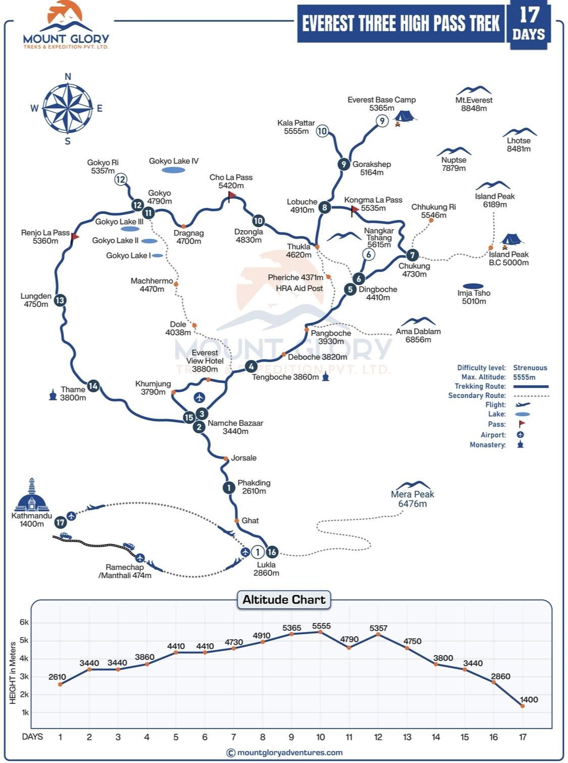
Details Everest Three Pass Trek 17 Days Map & Altitude Chart
In Nepal's Khumbu region, the Everest Three Passes Trek traverses remote high-altitude terrain and three major passes: Kongma La (5535 m), Cho La (5,420 m), and Renjo La (5,360 m). It is a strenuous but stunning and picturesque trek.
This high-altitude trek offers sweeping views of Everest, Lhotse, Makalu, and Cho Oyu while passing through a variety of landscapes, including several Sherpa villages, the Gokyo Lakes, the Ngozumpa Glacier, and high ridges.
Additionally, a detailed Everest Three Passes Trek Map is necessary for navigation, comprehending trail difficulty, organising daily stages, and tracking altitude gain on such a remote trek in the Everest region.
To lower the risk of altitude sickness, the trek map assists hikers in scheduling rest days and acclimatisation stops at strategic locations like Namche Bazaar, Thame, and Gokyo.
It helps with photography and itinerary planning by enabling hikers to see the entire route, including passes, high camps, valleys, and picturesque viewpoints.
By displaying emergency exits, water sources, and alternate routes in the event of inclement weather or trail obstacles, the map enhances safety.
Maps make the journey easier to handle and more pleasurable by estimating walking time, distance, and effort for each stage.
Mount Glory Treks offers a comprehensive Everest Three Passes Trek Map for your convenience before going trekking during our pre-trek meeting in Kathmandu.
This map provides hikers with a comprehensive overview of the entire route, including Kongma La, Cho La, and Renjo La passes, high camps, valleys, and viewpoints, as well as Everest Base Camp 5364m when combined with our standard Everest Three Passes Trek package.
17 Days Standard Everest Three Passes Trek Map Itinerary
Day 01: Fly to Lukla and trek to Phakding (2610m / 8562ft).
Day 02: Trek to Namche Bazar (3,440m / 11,285ft.).
Day 03: Acclimatize day in Namche Bazar.
Day 04: Trek to Tengboche (3860m / 12664ft.).
Day 05: Trek to Dingboche (4410m. / 14468ft.).
Day 06: Acclimatization day at Dingboche.
Day 07: Trek to Chhukung (4730m. / 15518ft.).
Day 08: Trek to Lobuche Via Kongma La Pass (4910m / 16108ft.).
Day 09: Trek to Everest Base Camp and back to Gorak Shep (5140m / 16863ft.).
The trek route then travels through Phakding (2610 m) before arriving at Namche Bazaar (3440 m), a significant hub for acclimatization and a Sherpa cultural centre.
After leaving Namche, you will travel to Thame (3,800 m), cross the Kongma La Pass (5,545 m), the first significant pass, and then descend to Lobuche (4,940 m).
The path continues to Dzongla (4,830 m), passes through Cho La Pass (5,420 m), the second-highest pass, and then descends to Thagnak (4,700 m).
After crossing Renjo La Pass (5,360 m), hikers arrive at the breathtaking Gokyo Lake area (4,790 m) and can choose to climb Gokyo Ri (5,357 m) for expansive views of the Himalayas.
The loop back to the trailhead is completed by following Dole, Machhermo, Namche Bazaar, and Lukla.
The Everest Three Passes Trek Map helps hikers visualize each stage, plan daily distances, and get ready for altitude changes by showing the entire loop, including passes, high camps, villages, rivers, glaciers, and important viewpoints.
Trekkers can ensure a safer and more confident trekking experience by studying the map and anticipating technical sections, acclimatization requirements, and potential weather challenges.
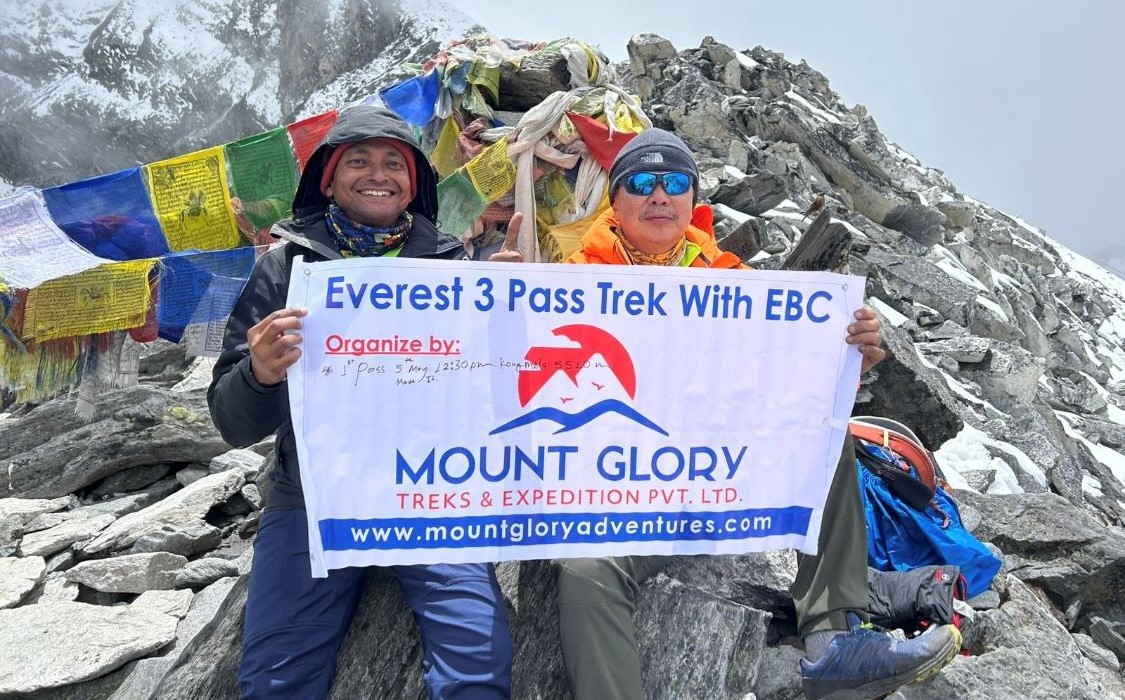
Mount Glory Treks Team on the way to Kongma La Pass 5535m during Everest Three Passes Trek
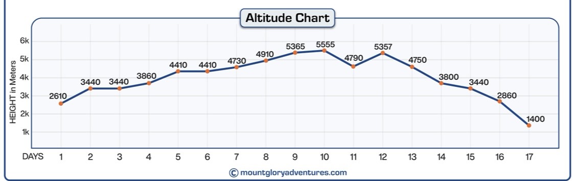
Elevation Profile of Everest Three Passes Trekking in Nepal
Anyone attempting the Everest 3 High Passes Trek needs to understand the elevation profile and distance chart. This route crosses three high Himalayan passes, Kongma La, Cho La, and Renjo La, where meticulous planning is crucial, in contrast to lower-altitude treks.
The trail begins at Lukla (2,860 m) and gradually climbs through rivers and rhododendron forests to Namche Bazaar (3,440 m), the centre of the Khumbu region's culture and acclimatization. Before going higher, Namche allows hikers to acclimatize to the thinner air.
The trail continues upward from Namche to Thame (3,800m), a peaceful Sherpa village that provides access to the high passes. The elevation chart indicates where the hardest work is needed, with Kongma La Pass (5,535 m) being the first significant climb, followed by the difficult Cho La Pass (5,420 m) and Renjo La Pass (5,360 m).
Important resting places like Gokyo (4,790 m), where hikers can take in breathtaking lake views and expansive peaks, are also tracked by the profile.
Trekkers can plan suitable rest and acclimatization days, visualize daily climbs, and anticipate steep sections or technically exposed terrain by using the elevation chart. Additionally, it aids in pace, allowing hikers to know when to use less energy and when to exert a little more effort. For the safety and comfort of those traversing all three passes, it is crucial to comprehend how altitude changes with distance.
The elevation profile, which works in tandem with a detailed map to ensure you move confidently from Lukla to Gokyo, across the high passes, and back, allows trekkers to fully enjoy the breathtaking landscapes, glaciers, and Himalayan vistas without needless surprises.
You can get a true sense of the demands of a daily trek by using elevation-linked distance charts. For instance, hikes over the passes typically span 8–12 kilometres (5–7.5 miles) with significant vertical gain, while approaches to high camps and viewpoints like Gokyo Ri are shorter but steeper.
Better pacing, energy management, and altitude planning are made possible by an understanding of both height and distance profiles, all of which are essential for comfort and safety on this strenuous Everest region trek.
Everest Three Passes Trek Altitude Chart Details in meters
Everest Three Passes Trek Map Awareness
Making decisions on the Everest Trek requires a strong sense of map awareness, particularly when the weather becomes erratic. Trail markings can be erased in a matter of minutes in high alpine terrain due to sudden snowfall, fog, or whiteout conditions.
A well-read trekking map helps trekkers and guides understand their position in relation to ridgelines, valleys, and passes, allowing them to make informed decisions about whether to continue, wait, or descend, which can mean the difference between a safe and risky day.
Safe rest areas, seasonal lodges, water sources, and designated descent routes are all prominently displayed on a thorough Three Passes trek map. Finding the closest safe drop-down valley is crucial when traversing high passes like Kongma La, Cho La, or Renjo La.
Maps make it easier to find bailout routes to villages like Dzongla, Thagnak, or Thame, which are vital choices in situations involving injuries, altitude problems, or deteriorating weather.
To ensure group safety, seasoned guides mainly rely on their familiarity with maps. In addition to following the main trail, guides use terrain markings, elevation contours, and distances to control pace, select safer routes in snow or ice, and designate rest areas that minimize exposure to wind and cold.
Map awareness becomes a potent safety tool that keeps the entire group focused, informed, and ready throughout the Three Passes Trek when paired with real-time observation and local knowledge.
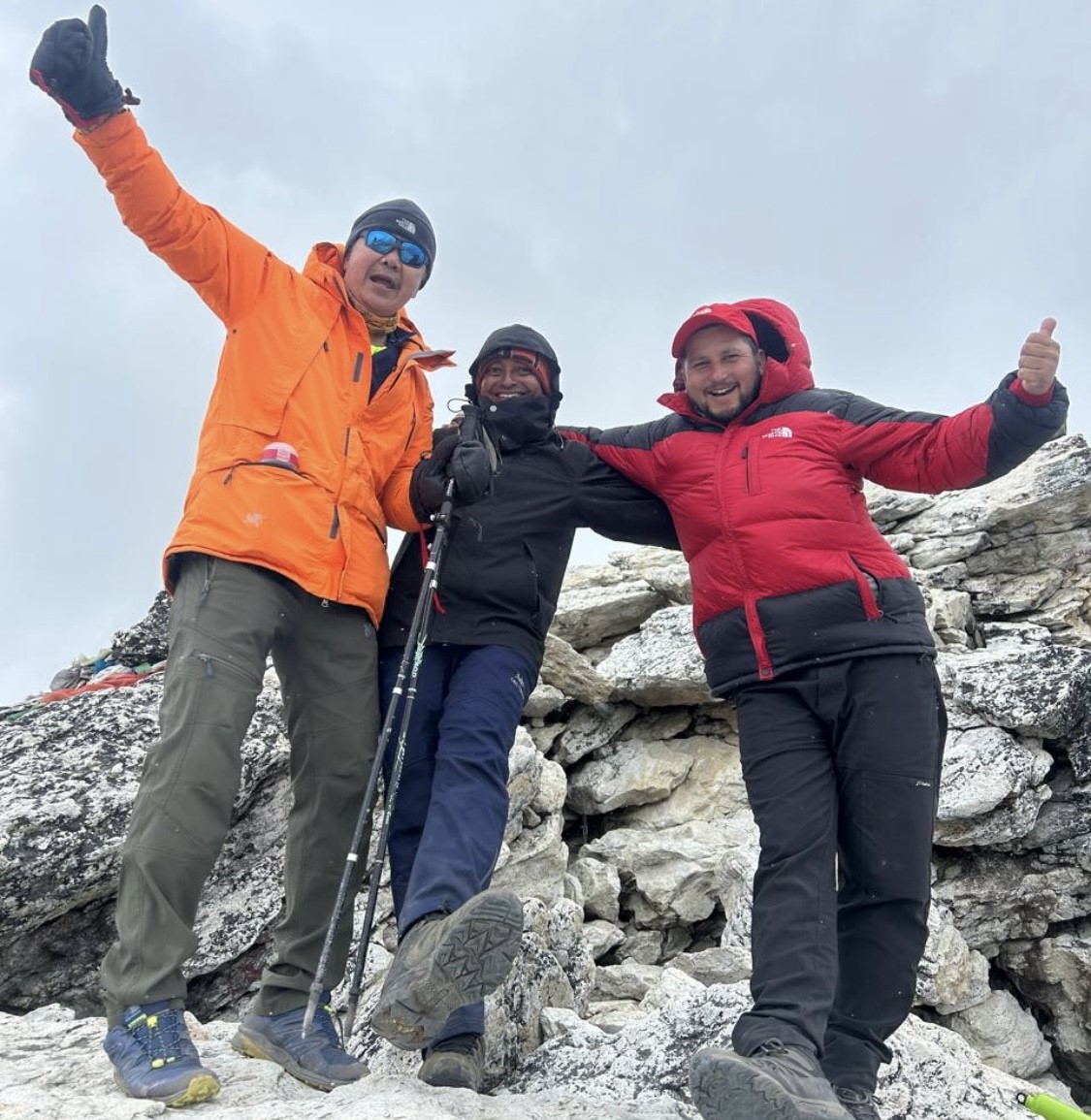
Trekkers and Mount Glory Treks experineced guide Enjoying with mountains during Three Passes Trek
In Conclusion
The Everest Three Passes Trek Map is much more than a simple route outline; it is an essential planning and safety tool that boosts confidence on one of the most difficult treks in the Everest region.
A well-researched map enables hikers to anticipate difficulties rather than respond to them on the trail, from comprehending elevation changes and daily distances to visualizing valleys, high camps, and emergency exit routes.
Trekkers can mentally prepare for significant highlights and challenges like Kongma La, Cho La, and Renjo La Pass by studying the map in conjunction with the comprehensive itinerary.
Even at very high altitudes, the trip feels organized and doable when you know where these passes are in relation to villages, rest days, and acclimatization points.
Map knowledge should always be combined with the knowledge of qualified local guides for the best and safest experience. Better decision-making, safer crossings, and a more seamless journey are guaranteed by their on-the-ground experience and precise map awareness.
When combined, the Everest Three High Passes Trek map and guide assistance transform a difficult journey into a well-thought-out, fulfilling Himalayan experience.
We also offer both clockwise and anti-clockwise Three Passes Trek options based on travellers’ interests, fitness, and hiking pace. Please check both of our package details for more information.
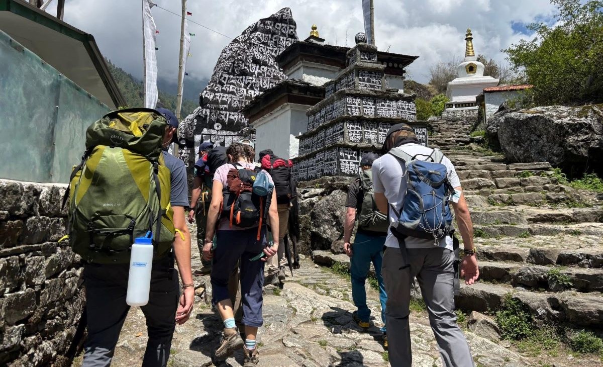
Travelers are on the way to Namche Bazaar during the Everest Three Passes Trek in the month of April.
Frequently Asked Questions
1: What information does an Everest Three Passes route map provide? The entire trekking circuit through the Khumbu and Gokyo regions is depicted on an Everest Three Passes route map, which includes villages, glaciers, high passes, altitude points, walking distances, and side trails. Instead of seeing the trek as discrete parts, it helps hikers comprehend how the route passes through Kongma La, Cho La, and Renjo La.
2: How is the Everest Three Passes trekking map different from standard Everest maps? Unlike basic Everest Base Camp maps, a Three Passes trekking map depicts a complete loop through multiple valleys and high crossings. It includes remote sections between Lobuche, Dzongla, Thagnak, and Gokyo that are not clearly marked on standard Everest region maps.
3: Why do experienced trekkers rely on detailed Khumbu trail maps for this trek? Long distances, glacier traverses, and abrupt altitude changes are all part of the Three Passes route. Trekkers can assess daily effort, locate rest villages, and anticipate difficult sections where weather or snow conditions may affect the trail with the aid of a comprehensive Khumbu trail map.
4: Does the map show walking distances and trekking hours accurately? Yes, a well-prepared map for the Everest High Pass trek includes average walking times and approximate distances between major stops. This enables hikers to plan realistic daily stages and avoid overexertion, particularly on pass crossing days.
5: How does an elevation profile help during the Everest Three Passes Trek? Trekkers can pace themselves and plan acclimatization with the aid of an elevation profile, which graphically displays altitude gain and loss throughout the entire route. Seeing the gradual climb from Lukla to Namche, as well as the steep ascents to Kongma La, Cho La, and Renjo La, improves preparation significantly.
6: Can the trekking map help in poor weather or low visibility conditions? Yes, map awareness is essential during snowfall, fog, or whiteout conditions at high altitudes. Knowing valley directions, descent routes, and nearby settlements on a map improves decision-making and reduces risk when visibility is low.
7: Are emergency exit routes marked on the Everest Three Passes map? Expert trekking maps show helicopter-accessible locations, safe descents, and alternate trails. These details are especially important near glacier sections and high passes, where conditions can change rapidly.
8: How do guides use route maps to manage group safety? Experienced guides frequently consult the trekking map to assess progress, adjust daily plans, and select safer routes based on weather and group conditions. Their local knowledge, combined with map data, ensures improved navigation and emergency preparedness.
9: Is a digital map or a printed map better for the Three Passes Trek? Each has a distinct function. While digital maps and GPS apps facilitate real-time location tracking, printed maps offer a comprehensive overview of the entire journey. For optimal accuracy, the majority of expert guides use both.
10: Should trekkers study the Everest Three Passes map before booking the trek? Trekkers who study the map ahead of time gain a better understanding of the physical demands, distances, altitude exposure, and overall commitment required. Additionally, it enables more thorough planning and reasonable expectations prior to embarking on one of Nepal's most challenging trekking routes.
Born and raised in the Mountainous village of Gorkha Nepal. Mr. Pandey is a successful tour leader and a very active social worker contributing a lot to the welfare of society. Mr, Pandey belongs to a very humble background and has started his career as a junior staff in a much-reputed company in Nepal. Mr. Pandey's family background is engaged in the tourism sector for an extended period. After spending many years in research and the drawbacks of tourism development.
Due to his great passion and enthusiasm for the trekking and tourism sector, he started his tour career with many expert teams. He intends to bring revolution to the tourism sector by offering luxurious services and accommodations to travelers at a minimum price. With the Motto of Travellers, satisfaction is my passion. He has been helping many travelers with traveling.


 4 reviews