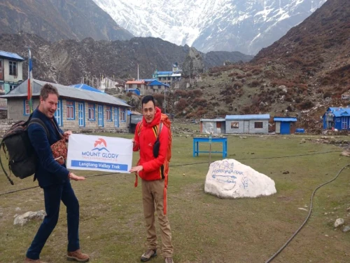
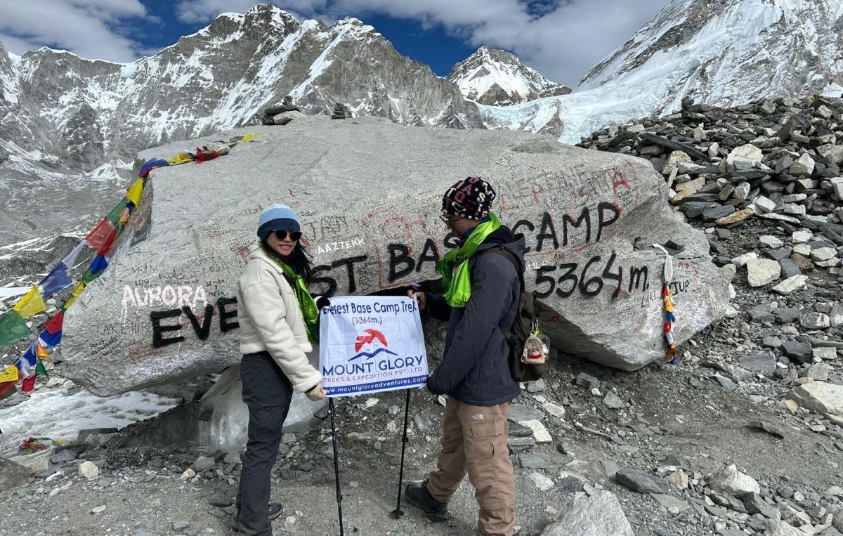
Couple from Singapore reached at Base Camp of Mount Everest 5364m
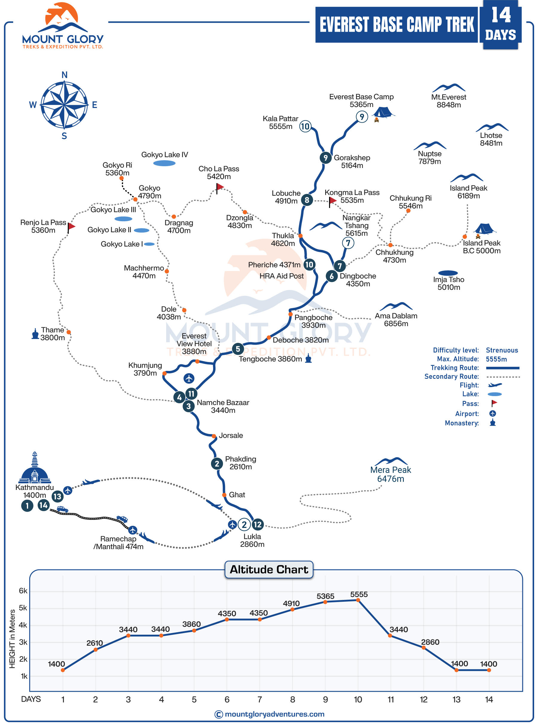
Everest Base Camp Trek Map is a legendary trail that leads to the base of the world's highest mountain. And many hikers dream of walking the same path taken by those who reach the summit of Everest.
A genuine high-altitude experience is walking in the shadow of Mount Everest (8848.86 m) in the centre of the Khumbu region.
You travel through the serene Sagarmatha National Park, a UNESCO World Heritage Site rich in alpine forests and wildlife, after taking a picturesque flight to Lukla, one of the world's most exciting mountain airstrips.
Experience the rich Sherpa culture, historic monasteries, and friendly hospitality in villages like Namche Bazaar and Tengboche as you continue to cross the famous suspension bridges on the traditional Himalayan trek to Everest.
Visit the serene Tengboche monastery, which offers expansive views of the Himalayas and serves as the spiritual hub of the Khumbu region.
For the best sunrise views of Everest, Nuptse, and Lhotse, hike to Kala Patthar (5,545 m), the highest point of the journey, and stand at the trek's ultimate destination, Everest Base Camp (5,364 m), next to the fabled Khumbu Icefall.
However, the Everest Base Camp Trek Map is one item that travellers should never overlook when getting ready for the journey. Additionally, a map is crucial for the Everest trek because it displays the main villages, river valleys, the standard Lukla-EBC trail, and the general route alignment through the Khumbu region.
Trekkers can better understand how quickly the trail rises into the high altitude terrain by using the EBC map, which highlights key elevation zones and altitude levels.
Above all, it designates significant overnight stops and landmarks like the Khumbu Glacier, Namche Bazaar, Tengboche, and Dingboche.
For a safe journey to the high altitudes, we will go into great detail about the Everest Base Camp Trek map in this article.
Everest Base Camp Trek Map Details
Everest Base Camp Trek 14 Days Map Outline Itinerary
The Everest Base Camp Trek is the world-famous adventure trekking route ranking 1, covering around 80 miles or 130 kilometres.
Here is the outline of the 14-Day EBC Trek Route Itinerary
Day 1: Arrival in Kathmandu and Pre-Trip Meeting. Day 2: Flight from Kathmandu (1,400m / 4,593ft) to Lukla (2,850m / 9,350ft). Trek to Phakding ( 2,650m / 8,562ft Day 3: Trek from Phakding (2,650m / 8,562ft ) to Namche Bazaar (3,440m / 11,285ft) Day 4: Rest day and acclimatisation at Namche Bazaar ( Hike to Everest View Hotel) Day 5: Trek from Namche (3,440m / 11,285ft) to Tengboche (3847m) Day 6: Trek from Tengboche (3,855m / 12,850ft) to Dingboche (4,360m / 14,290ft) Day 7: Rest day and acclimatisation at Dingboche(Hike to Nagarjun Hill) Day 8: Trek from Dingboche (4,360m / 14,290ft) to Lobuche (4,930m / 16,175ft) Day 9: Trek from Lobuche (4,930m / 16,175ft) to EBC (5,364m / 17,598ft) and back to Gorak Shep (5,185m / 17,010ft) Day 10: Hike to Kala Patthar (5,555m / 18,208ft) viewpoint, trek to Gorak Shep, then hike to Pheriche (4,250m/13,945ft) Day 11: Trek from Pheriche (4,250m / 13,945ft) to Namche Bazaar (3,440m / 11,285ft) Day 12: Trek from Namche Bazaar (3,440m / 11,285ft) to Phakding (2,650m / 8,690ft) Day 13: Trek from Phakding (2,650m / 8,690ft) to Lukla (2,850m / 9,350ft) Day 14: Fly back to Kathmandu (1400m / 4,593ft) from Lukla (2,850m / 9,350ft
The Everest base camp route is located in the Solukhumbu district in northeastern Nepal, near the border with Tibet (China).
In addition, the upper Khumbu region, a high-altitude Himalayan landscape with towering peaks and deep valleys, is traversed by the route to EBC.
Lukla sits serenely at the route's southern entrance, where the trail progressively climbs northward towards Everest.
The EBC Trekking Map clearly depicts the entrance to Sagarmatha National Park near Monjo, where permits are checked. Similarly, the majority of the trekking area is contained within the protected park zone, which prioritises conservation and restricted access.
Additionally, the map's park boundary makes it easier for people to recognise the restricted natural zones, settlements, and regulated areas.
In the lower part of the route, the Dudh Koshi River valley is closely followed, offering a gradual and organic climb. Detailed maps make it easy to see how the trail passes through exposed ridgelines and alpine basins as altitude rises.
The Everest map focuses on glacier terrain and moraine zones near Everest Base Camp, including the Khumbu Glacier, where the landscape becomes stark and rugged.
Everest Base Camp Trek Map: Starting Point to End Point
The lack of motorable roads in the upper Khumbu region makes Lukla the only feasible access point to the EBC trail. The majority of Everest treks, such as our 12-day Everest Base Camp Trek, start with a picturesque flight to Lukla.
Trekking from the lower valleys rather than flying would take several weeks longer and expose the travellers to unnecessary altitude and logistical challenges.
According to the trek map, the Everest trail climbs quickly and gradually from south to north, matching the Khumbu Valley's natural rise. Additionally, the main towns and rest areas are positioned strategically along the northward route, as is evident.
Witnessing the raw Himalayan beauty, this directional flow allows hikers to gain altitude gradually, which is necessary for proper acclimatisation.
Interestingly, the same trail is used for the descent because it provides dependable infrastructure, established lodges, and medical access. Although there are other ways to get back, they are constrained by the steep terrain, glacial barriers, and protected park areas.
Because of this, taking the same route down guarantees a quicker and safer return while preserving access to familiar, acclimated elevations.
Section-by-Section Breakdown of the Everest Base Camp Trek Map
Lower Khumbu: Lukla to Namche Bazaar
The lower part of the Everest trek, which leads from Lukla to Namche Bazaar along the Dudh Koshi River Valley, is the entrance corridor into the Himalaya. There are suspension bridges, small Sherpa villages, and mostly forested trails in this area.
Additionally, the trekkers can begin acclimatisation early because the elevation gain is gradual. The maps clearly identify Phakding and Monjon, two important settlements in the lower Khumbu, as overnight stops and permit checkpoints.
Mid Khumbu: Namche Bazaar to Dingboche
You will now travel through the mid-Khumbu region, where the EBC trail climbs through open valleys, terraced hills, and alpine ridges.
Namche Bazaar, a bustling village that frequently appears as a buffer zone on expert Everest maps, is a significant acclimatisation hub.
Additionally, locations like Dingboche, Pangboche, and Tengboche are ideally situated for gradual altitude gain. Additionally, you can see that the trekking maps depict the first panoramic views of Everest and Ama Dablam as well as the increasing proximity of glaciers.
Upper Khumbu: Dingboche to Everest Base Camp
The final part of the trek, the upper Khumbu region, is a high-altitude section that travels through Lobuche and Gorakshep, with trails traversing glacial terrain and rocky moraine.
The prime viewpoint, Kala Patthar, is located at 5,555 metres, while EBC itself is marked at 5,364 metres. Trekking map guidance is crucial for pacing and safety because you will notice that the terrain becomes exposed, rugged, and wind-prone.
Additionally, the highlighted buffer zones for acclimatisation to avoid acute mountain sickness (AMS) may be included on the map.
Everest Base Camp Trek Map Distance
The total round-trip distance from Lukla to the Everest Base Camp and back is about 130 kilometres, depending on optional side hikes. For the entire Everest trek, the map helps trekkers visualise the overall trail layout and anticipate the scale of the journey.
For your information, the daily trekking distances during the EBC journey can range from 5 to 12 kilometres, with shorter but more physically taxing days in the upper Khumbu and easier sections in the lower Khumbu.
The EBC Trek map makes it easy to plan energy and rest stops by showing you the terrain type and trail gradients.
Because of the steep, rocky terrain and reduced oxygen levels, even a 5-6-kilometre walk at elevations above 4,000 metres can be very taxing.
Additionally, the distance is less significant than pacing and acclimatisation due to the altitude, trail exposure, and moraines.
Trekkers can prevent overexertion on the trail and lower their risk of altitude sickness with careful map-based planning.
Everest Base Camp Trek Elevation Profile
The daily altitude gain must be understood in order to plan the Everest Base Camp trek and manage energy effectively.
Altitude sickness can become dangerous above 3,000–3,500 metres, especially in areas like Namche Bazaar, Tengboche, Dingboche, Lobuche, Gorakshep, and Everest Base Camp itself.
To lower the risk of Acute Mountain Sickness (AMS), acclimatisation stops like Namche Bazaar and Dingboche are crucial.
Trekkers can safely plan walking hours, rest periods, and optional side hikes like Kala Patthar with the aid of this clear daily elevation chart:
Location
Elevation in Meters
Kathmandu
1400m
Lukla
2860m
Phakding
2610m
Namche Bazar
3440m
Tengboche
3867m
Dingboche
4410m
Lobuche
4940m
Gorekshep
5164m
Everest Base Camp
5364m
Kalapatthar
5555m
Seasonal Changes That Affect the Trek Map
Glaciers and landslides may cause the trails to slightly alter, which could have an impact on how the EBC map is interpreted.
Trail alignment may be slightly altered by glacier movements, snow accumulation, and sporadic landslides, particularly in the vicinity of the Khumbu Glacier and moraine zones.
Expert trek maps showcase adaptable routes to safely traverse these natural shifts. And if you are travelling with a reputable travel agency like Mount Glory Treks rather than by yourself, these problems might not be an issue.
Spring (March–May): Trails are generally stable, rhododendrons bloom, and snow melts, making paths visible and scenic.
Autumn (September-November): Trails are drier, and the weather is clearer, offering panoramic mountain views. However, some sections may be dustier or rockier.
Winter (December - February): Snow and ice make higher sections, particularly near Lobuche and Gorakshep, slippery and slow to traverse.
Monsoon (June–August): Excessive rainfall can result in landslides, river swelling, and trail erosion, occasionally necessitating temporary detours.
Seasonal modifications, such as avoiding difficult areas or scheduling additional rest in specific villages, are indicated on trek maps. Expert advice is essential for safe trekking planning because simple tourist maps do not show seasonal hazards.
In Conclusion
For the Everest Base Camp Trek, selecting the appropriate map is crucial because expedition-grade maps are superior to tourist maps in terms of altitude, acclimatisation zones, and trail difficulties.
Avoid common mistakes like overestimating daily distances or ignoring buffer zones; instead, plan according to elevation gain rather than just distance. If you are on a guided trek, you should also follow your guide.
Understanding the route improves your chances of success on the trek by enabling you to pace appropriately and lower your risk of altitude sickness. Similarly, reading the map promotes a safer, more intelligent trekking mindset that allows you to take in the scenery and culture without hurrying.
To guarantee a safe and enjoyable trip to Everest Base Camp, Mount Glory Treks offers comprehensive maps, professional route guidance, and safety insights during the Trek package.
Frequently Asked Questions
1: How long does it take to complete the Everest Base Camp Trek Map? The trek typically lasts 12-14 days, depending on acclimatisation stops and optional side hikes such as Kala Patthar. Guided packages with us can help you plan your itinerary, balancing trekking pace and rest days for a safer ascent.
2: What is the total distance of the EBC Trek? The round-trip distance is approximately 130 kilometres, excluding flights. High altitude makes distances seem longer, so choosing a package with comprehensive route maps and professional advice can help you effectively manage daily distances.
3: Do I need previous trekking experience for Everest Base Camp? Although not required, prior trekking experience is beneficial. Even first-time high-altitude hikers can manage the route thanks to proper altitude sequencing, rest days, and guided assistance.
4: When is the best time to trek to Everest Base Camp? For stable trails and clear skies, spring (March–May) and autumn (September–November) are the best seasons. In order to guarantee safe trekking conditions and the best views, guided packages frequently recommend departures during these seasons.
5: What are the key stops along the Everest Base Camp route? Namche Bazaar, Tengboche, Dingboche, Lobuche, and Gorakshep are important locations. Selecting a guided itinerary with Mount Glory Treks guarantees that every stop is strategically utilised for rest, cultural experience, and acclimatisation.
6: How high is Everest Base Camp, and how difficult is the altitude? At 5,364 metres, the oxygen content is low at Everest Base Camp. Trekking at high altitudes can be safely managed with packages that include buffer days, gradual altitude gain, and professional guides.
7: Can I trek to Everest Base Camp independently using a map? Maps depict the trail, but professional advice is advised due to weather, high-altitude hazards, and difficult terrain. To guarantee a safe journey, Mount Glory Treks offers comprehensive route maps, GPS references, and knowledgeable guides.
8: What is the average cost of an Everest Base Camp trek in Nepal? Costs vary depending on group size, season, and inclusions. In addition to providing a safer and more memorable experience than separate arrangements, packages usually include lodging, porters, guides, and logistics. Depending on the size of the group, the 12-day EBC trek itinerary for Mount Glory Treks costs between $1090 and $1290.
9: Are there helicopter options along the Everest Base Camp trail? Trekking days can be shortened by using helicopter transfers for emergency evacuation or returning from Base Camp. Trekking and helicopter options are frequently combined in guided packages to accommodate fitness, time constraints, or safety requirements.
10:How can I prevent altitude sickness on the Everest Base Camp Trekking? Nutrition, adequate hydration, acclimatisation days, and gradual altitude gain are crucial. Planned rest stops and altitude sequencing are key components of a guided itinerary, which lowers the risk of AMS while guaranteeing a comfortable journey.
Born and raised in the Mountainous village of Gorkha Nepal. Mr. Pandey is a successful tour leader and a very active social worker contributing a lot to the welfare of society. Mr, Pandey belongs to a very humble background and has started his career as a junior staff in a much-reputed company in Nepal. Mr. Pandey's family background is engaged in the tourism sector for an extended period. After spending many years in research and the drawbacks of tourism development.
Due to his great passion and enthusiasm for the trekking and tourism sector, he started his tour career with many expert teams. He intends to bring revolution to the tourism sector by offering luxurious services and accommodations to travelers at a minimum price. With the Motto of Travellers, satisfaction is my passion. He has been helping many travelers with traveling.


 4 reviews
.webp)