The closest trek from Kathmandu's capital is the picturesque Langtang Valley Trek, which is located in the Langtang National Park to the north of the city. Because the trailhead at Syabrubesi can be reached by road from the capital in less than a day, it is regarded as one of Nepal's most accessible trekking routes.
However, this does not change the fact that the Langtang trek is perfect for both beginner and seasoned hikers because it offers a unique combination of alpine landscapes, dense forests, glacial valleys, and up-close mountain views.
The Langtang Valley offers a more tranquil trekking experience with fewer crowds than other busier routes in the Everest Base Camp Trek or Annapurna Base Camp Trek, all the while delivering breathtaking Himalayan scenery.
Additionally, the trail passes through traditional Tamang and Tibetan-influenced villages with monasteries, prayer wheels, and stone-built settlements, demonstrating the rich cultural diversity of Langtang.
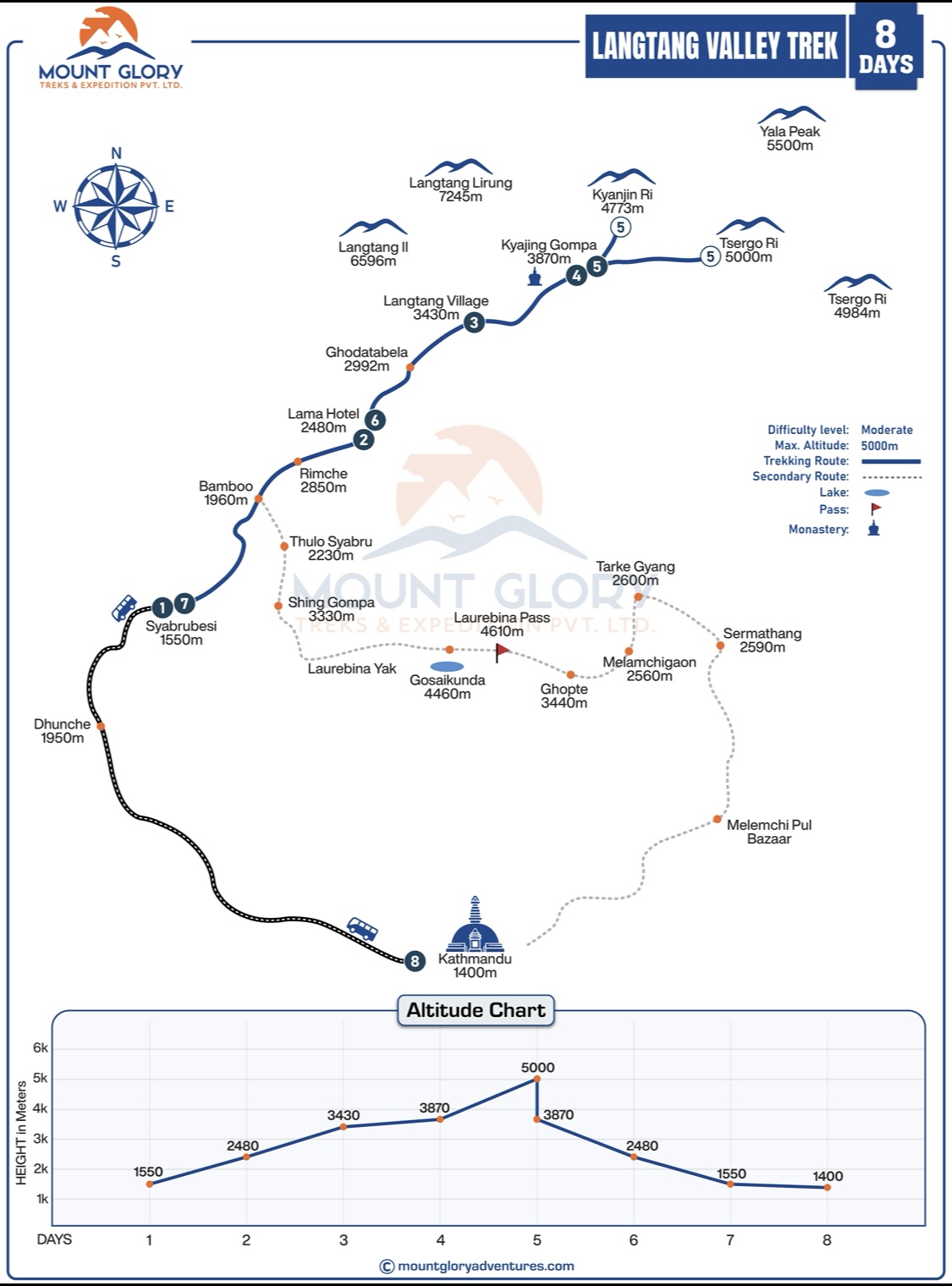
A Langtang Valley Trek map is essential for comprehending the entire trekking route, including the transition from lower forested trails to high-altitude alpine terrain.
Trekkers can see walking distances, elevation gain, and important stops like the Lama Hotel, Langtang Village, and Kyanjin Gompa thanks to the trek map's clear representation of daily trekking stages.
In order to properly acclimatise and prevent altitude-related problems, trekkers should study the map beforehand to better understand altitude changes.
The trek map also shows river crossings, suspension bridges, forest sections, landslide-prone areas, and open valley stretches to help prepare for changing terrain.
A detailed Langtang Valley Trekking map boosts navigation confidence among independent trekkers, particularly in areas where trails split or visibility is limited due to weather. Knowing the trekking map improves general awareness of the path, daily objectives, and surrounding landmarks, even for guided hikers.
The entire trekking route, beginning at Syabrubesi, the primary road-access trailhead north of Kathmandu, is clearly displayed on the Langtang Valley Trek map.
Shown on the map, the trail progressively follows the Langtang Khola river from Syabrubesi into dense forests of rhododendron, oak, pine, and bamboo.
There are suspension bridges, narrow river valleys, and areas of shaded forest along the route to the Lama Hotel.
Additionally, as the map illustrates, the trail opens up beyond the Lama Hotel, with broader valleys and better views of the mountains as hikers approach Langtang Village.
Situated in an open valley beneath nearby peaks, Langtang Village is highlighted on the map as a significant cultural and historical destination.
From Langtang Village, the Detailed Langtang Valley Trek Map shows a shorter but steeper route leading to Kyanjin Gompa, the highest overnight point of the trek.
On the map, Kyanjin Gompa is shown as a central hub with side trails leading to glaciers and viewpoints.
For ease of planning and navigation, the return route takes the same path back to Syabrubesi, which is prominently displayed on the map.
Compared to multi-pass treks, the Langtang Valley Trek map makes it easier to see how the trail stays inside a single, lengthy valley. Trekkers can anticipate changes in the landscape thanks to the map's clear representation of forest sections, river crossings, and exposed alpine terrain.
In the upper valley close to Langtang Village and Kyanjin Gompa, in particular, the map aids hikers in understanding where mountain views become more noticeable.
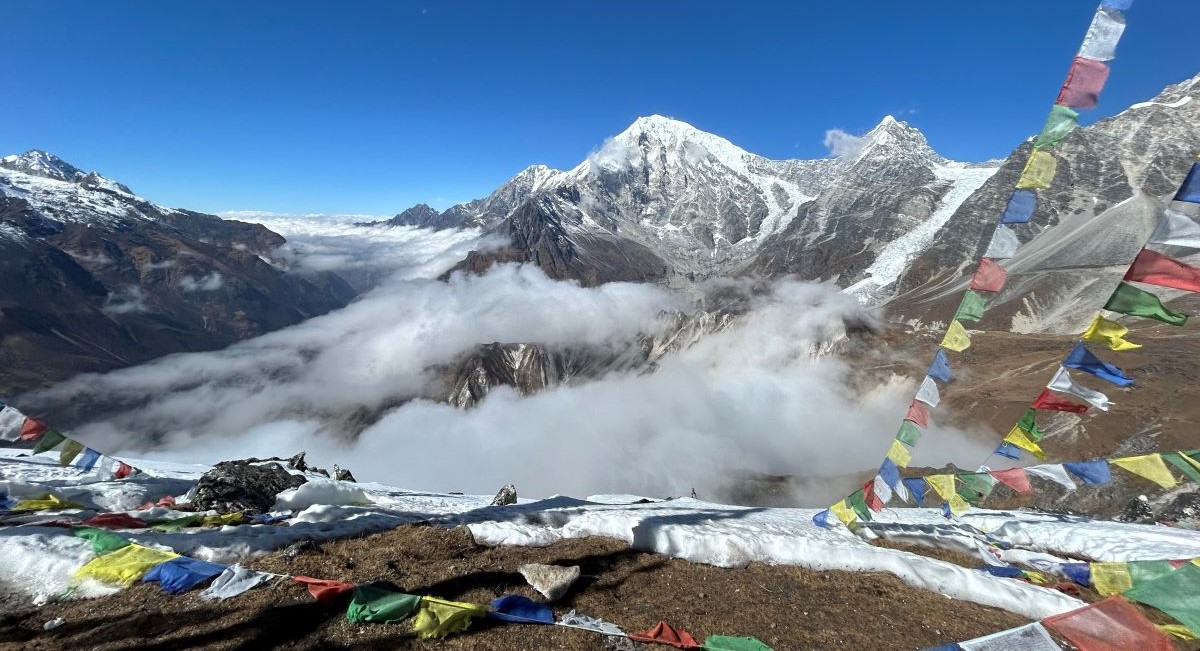
Himalayan View During Langtang Valley Trek
Langtang Valley Trek Map Key Sections
Starting Point on the Map: Syabrubesi
As we've already mentioned a few times, Syabrubesi is designated as the primary starting point on the Langtang Trek map. Additionally, Syabrubesi is shown on the map as the gateway village where the trekking trails start, and the road access ends.
Similarly, the map from this location indicates that the trail passes through river valleys and subtropical forests along the Langtang Khola. The terraced fields, tiny villages, and traditional settlements strewn along the lower trails are highlighted in the map's early sections.
Syabrubesi to Lama Hotel
This section, which follows forested trails along the Langtang Khola with numerous suspension bridges and a steady elevation gain, is clearly visible from Syabrubesi. Trekkers can better pace themselves by using the elevation markers on the map, which show a gradual ascent rather than steep climbs. Additionally, the distance and daily walking hours are displayed, which facilitates overnight stops and rest stops prior to arriving at the Lama Hotel.
Lama Hotel to Langtang Village
This section of the trek map clearly shows how the terrain shifts from dense forests to broader valleys and more open areas. The locations of the Langtang Lirung and the nearby Himalayan peaks are designated as key viewpoints along this route. Additionally, the detailed route map provides hikers with a clear understanding of the geography and history of the area by displaying towns and memorial sites close to the Langtang village.
Langtang Village to Kyanjin Gompa
You should prepare for slower walking days because higher altitude areas on the map show thinner air and more exposed trails. Follow your Guide and get in touch with them right away if you're feeling sick or experiencing symptoms.
Along the Langtang Valley's path, significant landmarks like yak pastures, monasteries, and seasonal settlements are prominently displayed. The glacier viewpoints and picturesque side paths near Kyanjin Gompa are highlighted, illustrating the areas where the terrain becomes more dramatic and alpine.
High Points Near Kyanjin Gompa
The majority of trek maps frequently indicate side hikes, like Tserko Ri, which highlights the summit altitude and steep elevation gain for better acclimatization planning. Similarly, the route maps prominently display the Yak Cheese Factory as a cultural and rest stop close to Kyanjin Gompa. Before attempting higher climbs, hikers can visualize trail difficulty, exposure, and viewpoint rewards with the aid of elevation profiles and photo markers on maps.
Returning Trail on the Map
Trekkers can familiarise themselves with the route ahead of time by using the Langtang Trekking Map, which clearly depicts the same trail back from Kyanjin Gompa through Langtang Village, Lama Hotel, and down to Syabrubesi.
Seeing the descent on a map helps trekkers plan for longer downhill sections, river crossings, and forested paths that require careful footing despite losing altitude.
In order to ensure a safe and efficient descent back to the trailhead, map awareness is particularly crucial for locating villages, rest areas, and daily walking distances.
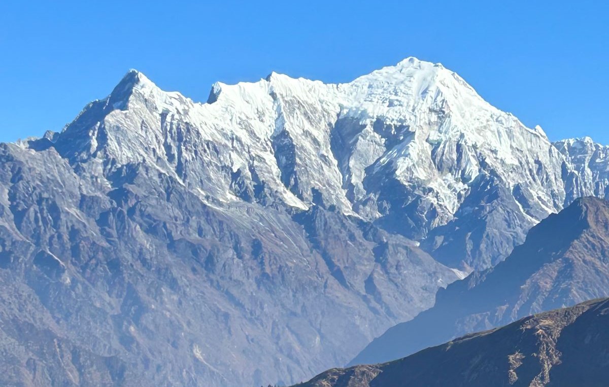
Langtang Mountain Range
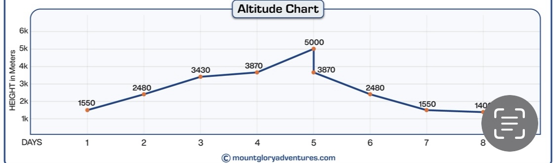
Langtang Valley Trek Elevation
Understanding the elevation profile is crucial for appropriate planning and acclimatization because the Langtang Valley Trek goes from the lower Himalayan foothills to high alpine zones close to Kyanjin Gompa.
The walk progressively climbs through open alpine terrain, river valleys, and subtropical forests; the highest altitude difficulties arise above 3,000 metres.
Allowing your body to acclimatize to lower oxygen levels, rest days and acclimatization stops, particularly in locations like Langtang Village, helps lower the risk of Acute Mountain Sickness (AMS).
Trekkers can plan daily walking distances, rest periods, and side trips to viewpoints more efficiently with the aid of a clear elevation chart, making their journey safer and more pleasurable.
Langtang Trek Altitude Map
Location: Elevation in Metres
Syabrubesi: 1,500 metres
Lama Hotel: 2,380 metres
Langtang Village: 3,430 metres
Kyanjin Gompa: 3,870 metres
Viewpoint of Tserko Ri: 5,035 m
In Conclusion
The trip is much simpler when you have a Langtang Valley Trek Map with you. It helps you see the path ahead, identify important villages, forests, rivers, and alpine meadows, and comprehend how the terrain and altitude will change daily from Syabrubesi to Kyanjin Gompa. You can unwind, take in the scenery, and enjoy the walk without worrying about getting lost if you know the route.
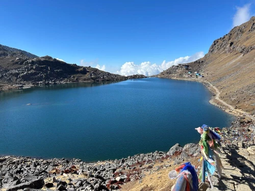
If you have the time, you can extend the trek to Gosaikunda Lake, which is a beautiful and spiritual side trip that many hikers enjoy. In order to make the trek feel difficult but doable, you can plan rest stops, pace yourself on steeper sections, and get ready for higher altitudes by studying the map before you go.
Lastly, a map provides confidence and safety, making the Langtang Valley experience far more rewarding.
If you prefer, you can combine this with a guided trek from Mount Glory Treks, which includes accommodations, meals, and planning so you can simply enjoy every moment of this breathtaking Himalayan valley.
For more details, the plan for the Langtang Region of Nepal
1: What does a Langtang Valley Trek map show in detail? The trekking route from Syabrubesi to Lama Hotel, Langtang Village, and Kyanjin Gompa, as well as daily elevation gain, walking distances, river crossings, forest sections, and neighbouring Himalayan peaks, are all clearly shown on a map of the Langtang Valley Trek. It aids hikers in visualizing the landscape and comprehending how the trail progressively transitions from high-altitude landscapes to subtropical forests.
2: Is the Langtang Valley Trek route easy to follow without a guide? Even though the Langtang Valley route is clearly marked and frequently hiked, a thorough trek map is still necessary. Although the trail is simple, it can be confusing due to side paths, landslides, and weather changes. Trekkers can navigate more easily and maintain their confidence with the aid of a map, particularly in longer forest sections and at higher elevations.
3: Where does the Langtang Valley Trek start and end? The journey starts in Syabrubesi, a small town north of Kathmandu, and travels to Kyanjin Gompa by following the valley of the Langtang River. The trek map makes it simple to schedule daily walking hours and rest stops because the return trip follows the same trail.
4: How does the trek map help with altitude awareness? Elevations at important villages like Lama Hotel, Langtang Village, and Kyanjin Gompa are marked on a map of the Langtang Valley Trek. Avoiding quick ascents helps hikers plan their acclimatization, keep an eye on their altitude gain, and lower their risk of altitude sickness.
5: What are the highest points shown on the Langtang Valley Trek map? Along with neighbouring vantage points like Tserko Ri, the map shows Kyanjin Gompa as the highest place to spend the night. Trekkers can assess the physical difficulty and determine whether optional side hikes are appropriate for their level of fitness with the aid of these elevation markers.
6: How long is the Trek to Langtang Valley according to the route map? The Langtang Valley Trek normally takes 7 to 10 days, depending on walking speed, acclimatization days, and side trips around Kyanjin Gompa, according to the standard route depicted on the map. The map helps in dividing the trip into manageable daily phases.
7: Does the Langtang Trek map show accommodation points? Yes, the majority of trek maps show important teahouse locations like Kyanjin Gompa, Langtang Village, and Lama Hotel. Trekkers can better manage their energy levels and plan overnight stays by being aware of these locations beforehand.
8: What kind of terrain is visible on the Langtang Valley Trek map? The map shows a variety of open alpine terrain, river valleys, glacial landscapes, suspension bridges, and forested trails. This provides hikers with a clear picture of what to expect every day, from exposed high-altitude paths to walks through shaded forests.
9: Can the trek map help with weather and seasonal planning? Trekkers can better understand altitude and terrain, which are closely related to weather conditions, even though the map itself does not display the weather. The map makes it simple to predict that higher areas close to Kyanjin Gompa are windier and colder.
10: Is the Langtang Trekking map useful for beginners? Yes. The map provides comfort for novice hikers by clearly displaying village locations, elevations, and distances. Because of this, when done correctly, the Langtang Valley Trek is among the easiest Himalayan treks for beginners.
11: Does the map include cultural and scenic landmarks? Monasteries, yak pastures, and traditional Tamang villages are marked on numerous maps of the Langtang Valley Trek. These specifics enable hikers to enjoy the cultural aspects of the journey in addition to the scenery of the mountains.
12: How accurate are the Maps of the Langtang Valley Trek compared to GPS apps? In remote locations with erratic mobile networks, printed trek maps are frequently more dependable. While a physical map offers constant reference during the journey, GPS apps can quickly deplete battery life.
Born and raised in the Mountainous village of Gorkha Nepal. Mr. Pandey is a successful tour leader and a very active social worker contributing a lot to the welfare of society. Mr, Pandey belongs to a very humble background and has started his career as a junior staff in a much-reputed company in Nepal. Mr. Pandey's family background is engaged in the tourism sector for an extended period. After spending many years in research and the drawbacks of tourism development.
Due to his great passion and enthusiasm for the trekking and tourism sector, he started his tour career with many expert teams. He intends to bring revolution to the tourism sector by offering luxurious services and accommodations to travelers at a minimum price. With the Motto of Travellers, satisfaction is my passion. He has been helping many travelers with traveling.


 2 reviews