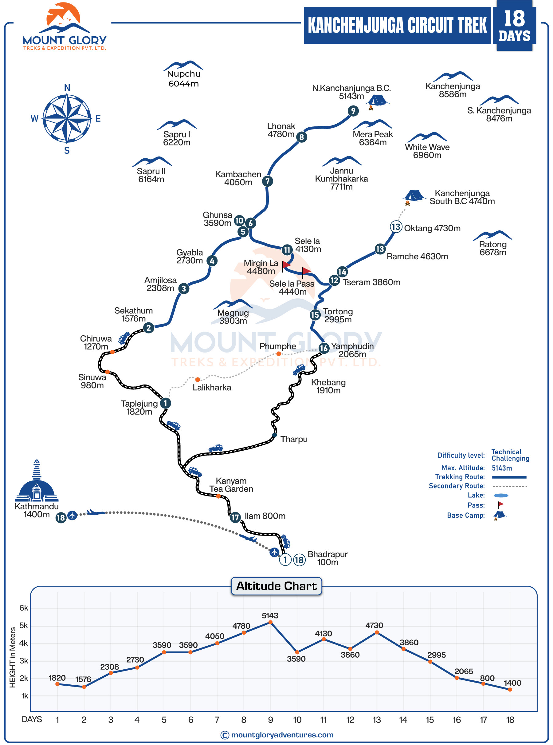
Kanchenjunga Circuit Trek Map Overview
The Kanchenjunga trek map provides a clear view of the entire trekking route, making it easier to comprehend how the trail winds through high passes, forests, valleys, and glacier areas. This makes it easier for you to see the daily trekking stages, the distance between villages, and the natural flow of the journey from the lower hills to the Himalayas.
Trekkers can track the elevation gain, acclimatisation points, and the highest parts of the trail thanks to the Kanchenjunga Circuit Map's clear altitude profile, which is one of its main benefits.
The map makes route planning simpler and more dependable by highlighting significant locations like Ghunsa Valley, Kambachen, Lhonak, Pangpema (North Base Camp), Tseram, and Oktang (South Base Camp).
Major high passes like Sele La, Mirgin La, and Sinelapche La, some of the most difficult but picturesque parts of the Kanchenjunga region trek, are visible to hikers.
Since it divides the trek into wilderness sections where services are scarce, and self-reliance becomes crucial, you can get practically all the information you need for the trip. This helps hikers prepare both logistically and psychologically.
In this restricted trekking area, the map facilitates improved coordination with local porters, trekking guides, and logistics teams for those organising a guided trip.
Understanding the Kanchenjunga Circuit Trek map is the first step for serious hikers and adventurers who want to experience one of Nepal's most genuine, difficult, and picturesque Himalayan treks.
Necessary Permit about Kanchenjunga Circuit Trek in Nepal
Kanchenjunga Circuit Trek Itinerary
The itinerary for the Kanchenjunga Circuit Trek is determined by the route, days for acclimatisation, and personal preferences.
Mount Glory Treks provides an 18-day Kanchenjunga Circuit hike that begins and ends in Kathmandu, covering all of the area's attractions.
- Day 01: Fly to Bhadrapur and drive to Taplejung.
- Day 02: Drive to Sekathum.
- Day 03: Trek to Amjilosa.
- Day 04: Trek to Gyabla.
- Day 05: Trek to Ghunsa.
- Day 06: Acclimatisation day at Ghunsa.
- Day 07: Trek to Kambachen.
- Day 08: Trek to Lhonak.
- Day 09: Hike to Kanchenjunga Base Camp.
- Day 10: Trek back to Ghunsa.
- Day 11: Trek to Sele La Kharka.
- Day 12: Trek Over Sele La Pass – Trek Down to Tseram.
- Day 13: Trek to Oktang (South Base Camp (4730m) and Back to Ramche.
- Day 14: Trek Back to Tseram.
- Day 15: Trek to Tortong.
- Day 16: Trek to Yamphudin.
- Day 17: Drive to Kanyam, Ilam.
- Day 18: Drive to Bhadrapur and fly back to Kathmandu.
For More Details about Planning for the Best Time to Do the Kanchenjunga Trek
Kanchenjunga Circuit Trek Map Sections
Starting Point: Kathmandu to Taplejung
Starting in Kathmandu and travelling to eastern Nepal, the Kanchenjunga Circuit signifies the transition from urban areas to isolated mountainous areas. The majority of trekkers take a plane from Kathmandu to Bhadrapur, after which they travel by road to Taplejung.
If you have more time and wish to experience the entire trip, you can opt for the full overland route that passes through Ilam and Phidim.
Additionally, this section of the trek map illustrates how the route transitions from the bustling cities to the peaceful rural foothills of Kanchenjunga, setting you up for the adventure and solitude that lie ahead.
The map also clearly shows where flights end, road travel begins, and trekking trails officially begin, allowing visitors to understand the entire access route to the Kanchenjunga region.
Lower Hills and Jungle Section
The official trekking trail begins at locations like Chirwa and Sekathum, which are also marked on the Kanchenjunga map as important points of entry into the Kanchenjunga conservation area.
Additionally, this section of the trekking map features dense forests, suspension bridges, and river valleys that indicate a gradual ascent through the subtropical landscape.
As you proceed with the map, you can see the early portions of the trip, where the trail winds through the warm and verdant landscapes, following the Tamor and Ghunsa rivers.
Middle Altitude Villages
You can track the elevation gain by using the altitude markings that appear as the circuit map ascends to villages like Gyabla and Amjilosa.
This section of the route demonstrates the transition from jungle to oak and rhododendron forests with narrower mountain paths and rougher trails.
It's interesting to note that the map also indicates significant rest areas and teahouses, which makes this area crucial for daily scheduling and pacing.
Ghunsa Valley
Every Kanchenjunga trekking map highlights the well-known location of Ghunsa as a significant centre for acclimatisation and culture. Additionally, the map shows how Tibetan culture and way of life have influenced the transition from forested hills to the high Himalayan valleys.
You will start to experience the true alpine environment in this part of the trek, and the map does a great job of capturing this change in terrain.
North Route
The northern portion of the Kanchenjunga circuit, from Kambachen to Lhonak and Pangpema, the north base camp, is depicted on our comprehensive trek map.
Glaciers, rocky moraines, and expansive alpine valleys characterise this area, which offers some of the most breathtaking scenery and unforgettable experiences of the entire trek.
Most significantly, this portion of the northern route is the highest and most difficult on the trek map.
High Passes and Ridge Crossings
You can see that the map completes the elevation details by highlighting significant passes like Sele La, Mirgin La, and Sinelapche La.
The entire Kanchenjunga circuit, which links the mountain's north and south faces, is built around these passes. Trekkers can better understand where the most difficult days are and how the route changes between valleys by carefully studying this section of the map.
South Base Camp
As you proceed, you reach Oktang, the south base camp of Kanchenjunga, via the southern route of the Himalayan trek from Tseram. Wide glacial basins, high ridges, and serene alpine scenery are suggested by the map. Trekkers can see the Kanchenjunga mountain from a different angle because the scenery here is very different from that of the north side.
Routes Back – Completing the Circuit
After finishing the circuit trek, the map shows a descent route through Ramche, Tortong, and Yamphudin that returns hikers to the lower hills and warmer climates. This section will show you how the trail completes the geographical journey from the high Himalayas to the mid-hills by progressively returning to the forest zones and terraced farmlands.
The fact that the map depicts the trek as a true circuit rather than an out-and-back route is one of its most significant features. This looping design distinguishes the Kanchenjunga circuit from other circuit treks, allowing you to explore both sides of the mountain via distinct trails.
Kanchenjunga Circuit Trek Difficulty Level in Details
Kanchenjunga Circuit Trek Elevation Profile
Since the Kanchenjunga Circuit Trek travels through some of Nepal's most isolated and high-altitude regions, it is crucial to comprehend the elevation profile of the route for careful planning and safe trekking.
Above 3,500 metres, altitude-related difficulties worsen, particularly in the vicinity of Ghunsa, Kambachen, Lhonak, Pangpema (North Base Camp), Tseram, and Oktang (South Base Camp).
Acclimatisation stops at important villages like Ghunsa and Kambachen, which are essential to lowering the risk of Acute Mountain Sickness (AMS). Before heading into the higher alpine zones close to the base camps and mountain passes, these rest days give your body time to gradually adjust.
The lengthy and difficult Circuit journey can be made safer, easier, and more pleasurable for hikers by using a clear daily elevation chart to better plan walking hours, rest periods, and side trips.
| Locations | Elevation in Meters |
| Kathmandu | 1400m |
| Bhadrapur | 93m |
| Taplejung | 1820m |
| Chirwa | 1270m |
| Sekathum | 1650m |
| Amjilosa | 2300m |
| Gyabla | 2730m |
| Ghunsa | 3475m |
| Kambachen | 4145m |
| Lhonak | 4780m |
| Pangpema (North Base Camp) | 5140m |
| Sele La Pass | 4290m |
| Tseram | 3870m |
| Oktang (South Base Camp) | 4730m |
| Tortong | 2995m |
Yamphudin | 2080m |
Tips during your journey to the Kanchenjunga Circuit
- Before you set out on a Kanchenjunga trek, here are some helpful suggestions from our team of knowledgeable guides and staff that will make your journey easier and prevent issues:
- Even if you use digital navigation, always have a printed copy of the Kanchenjunga Circuit Trek map on hand as a backup. We also give trekkers a comprehensive map prior to any treks. Paper doesn't die like batteries do.
- Before departing Kathmandu, download offline GPS maps (such as those from Maps.me or Gaia GPS), as the mobile signal becomes spotty after Taplejung.
- Mark key locations on your map, such as Ghunsa, Kambachen, Lhonak, Pangpema, Tseram, and Oktang, to facilitate tracking your daily progress.
- To ensure that everything crucial is in one location, keep your trekking permits (TIMS and Kanchenjunga Conservation Area Permit) with your map.
- To avoid hurrying into high-altitude areas above 3,500 metres, use the trek map in conjunction with your acclimatisation schedule.
- Every evening, review the route with your guide or group leader to gain an understanding of the terrain, distance, and altitude gain for the next day.
- In order to avoid making incorrect turns, pay close attention to isolated intersections and high passes like Sele La and Mirgin La.
- Before the trek, familiarise yourself with contour lines and basic map symbols to help you assess long ascents and steep sections.
Food & Accommodation On the way to Kanchenjunga Circuit Trek Route
In Conclusion
A trek map is by far the most crucial tool for organising any trip to remote and high-altitude areas. You should not overlook the Kanchenjunga Circuit Trek Map while travelling because it aids hikers in comprehending the entire circuit route from the lower hills of Taplejung to the high alpine zones close to Pangpema and Oktang.
Don't be like me; on treks, I used to frequently forget the maps and rely primarily on digital maps, which are less reliable in remote areas with unstable networks. As a result, I frequently encountered problems.
Therefore, I advise you to understand how to read a trek map, and hopefully, this article helped you realise how important it is to have one.
Knowing the trail layout ahead of time increases confidence and safety for a trek that passes through some of Nepal's most remote valleys.
For your information, we provide an 18-day Kanchenjunga circuit trek with suitable duration, acclimatisation days, flexible itineraries, all required facilities, and expert assistance throughout the trek to ensure the best possible experience. For the best deals, book your trek with Mount Glory Treks right away to avoid missing any of the Kanchenjunga region's highlights.
More about Complete Packing List For Kanchenjunga Trek
Frequently Asked Questions
1: What does the Kanchenjunga Circuit Trek map show?
The entire route around Mount Kanchenjunga, including important villages, high passes, base camps, altitude points, and daily trekking sections, is shown on the Kanchenjunga Circuit Trek map. Before starting this far-off Himalayan journey, it helps hikers visualise the terrain, distances, and elevation changes.
2: Why is a trek map important for the Kanchenjunga Circuit?
Since this is one of the most isolated trekking routes in Nepal, preparation requires a thorough map. It enables you to understand the trail, acclimatisation days, and your journey through high mountain passes, glaciers, valleys, and forests.
3: Where does the Kanchenjunga Circuit Trek start on the map?
The majority of maps depict the trek starting in eastern Nepal's Taplejung district, followed by a flight to Bhadrapur and a quick drive to the trailhead. After that, the trip progressively ascends through towns like Chirwa and Sekathum before going farther into the mountains.
4: Does the map include both North and South Base Camps?
Yes, a proper Kanchenjunga Circuit Trek map shows both the North Base Camp (Pangpema) and the South Base Camp (Oktang). This creates a complete loop instead of an out-and-back path, which distinguishes the trek.
5: What are the highest points shown on the Kanchenjunga Circuit Trek map?
At about 5,143 metres, North Base Camp is located alongside high passes like Sele La, Mirgin La, and Sinion La. For a safe journey, these high-altitude sections call for a cautious pace and appropriate acclimatisation.
6: Can beginners use the Kanchenjunga Circuit Trek map?
Trekkers of all skill levels can benefit from the map, but experienced or well-prepared hikers are best suited for the circuit itself. Beginners can determine whether the trek is appropriate for their level of fitness and trekking experience by looking at the elevation profile and daily distances.
7: How accurate are online Kanchenjunga Circuit Trek maps?
Modern trekking maps, particularly those that use GPS, are generally accurate. However, using the map in conjunction with a licensed guide is always advised because trail conditions can alter due to weather or landslides.
8: Does the trek map show accommodation points?
Yes, important overnight stops like Ghunsa, Kambachen, Lhonak, Tseram, and Yamphudin are shown on most maps. Trekkers can more efficiently plan daily distances and rest days if they are aware of the locations of teahouses and villages.
9: How does the map help with altitude acclimatisation?
The map assists in identifying areas where the terrain rises rapidly and where rest days are required by displaying elevation gain for each day. For appropriate acclimatisation, the areas surrounding Ghunsa and Kambachen are crucial.
10: Is the Kanchenjunga Circuit Trek route clearly marked on the trail?
While trail markings may be scarce in isolated alpine regions, lower sections are typically well-marked. Throughout the journey, safe navigation is ensured by using a map and a knowledgeable guide.
11: Can I use a digital map instead of a printed one?
Yes, a lot of hikers use printed maps and offline GPS applications. Having both digital and paper maps adds an extra layer of security because the mobile signal is frequently spotty in this area.
12: How long does the full circuit look on the map?
Depending on route variations and acclimatisation plans, the Kanchenjunga Circuit Trek map usually indicates a journey of 16 to 24 days. This is one of the most comprehensive and daring treks in Nepal because of its length and topography.
13: Does the map include cultural and conservation areas?
Yes, the route goes through the Kanchenjunga Conservation Area and features villages influenced by Limbu, Rai, Sherpa, and Tibetan cultures. This demonstrates that the trek is about more than just the mountains; it also involves local life and heritage.
14: Why should I study the Kanchenjunga Circuit Trek map before booking?
You can prepare for the trek's difficulty, remoteness, and daily walking demands by understanding the map before making a reservation. It assists you in selecting the ideal time of year, engaging in physical training, and organising a secure, fulfilling Kanchenjunga journey.

 2 reviews