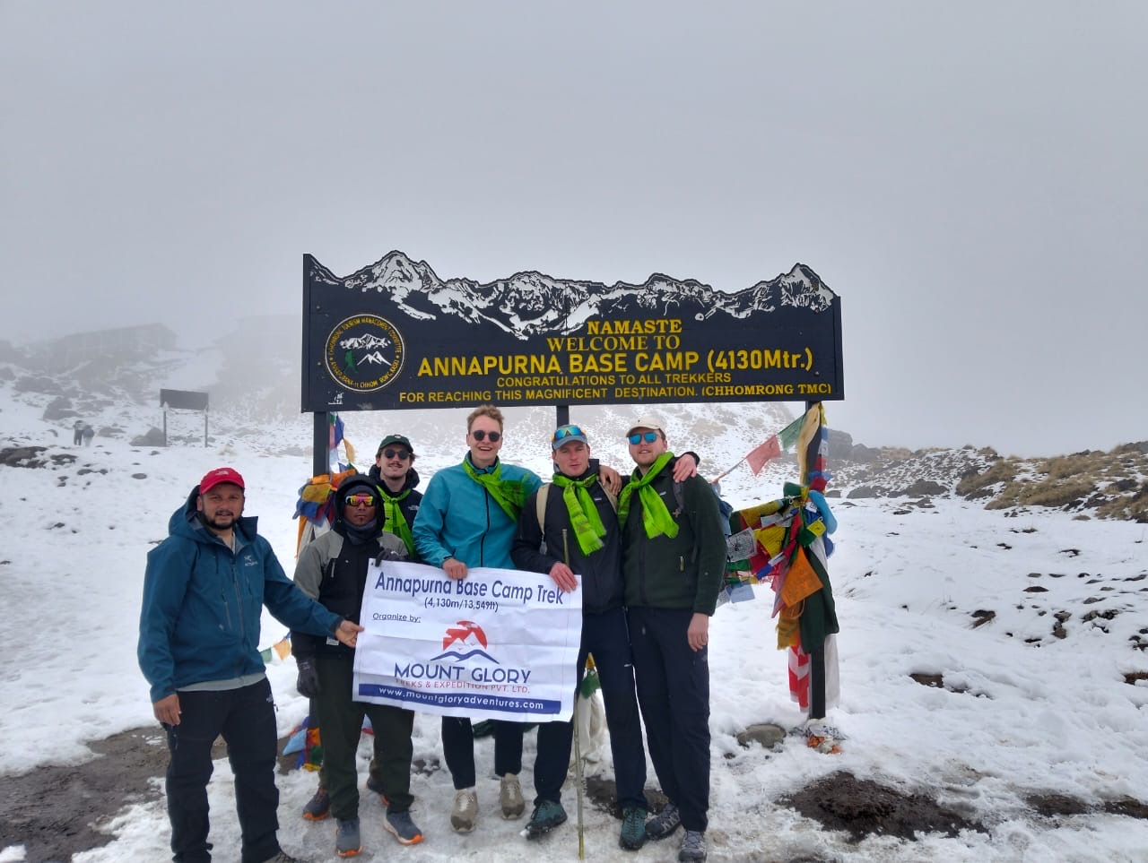
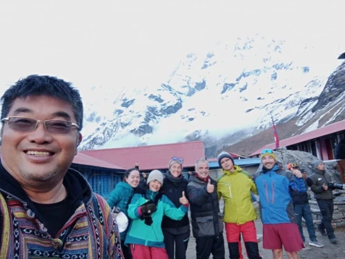
Mount Glory Treks Team at Base Camp of Annapurna 4130m
Annapurna Base Camp Trek takes you deep into the Annapurna Sanctuary, which offers the rare close-up views of Annapurna I (8,091 m), the 10th highest mountain. Furthermore, it offers views of beautiful peaks like Machapuchhre (fishtail), Hiunchuli, and Annapurna South, which makes this trek one of the most scenic short treks in Nepal.
Witness the diverse landscapes, from lush rhododendron forests and terraced farmlands to alpine meadows and glacial moraines. The Trek to ABC showcases Nepal’s dramatic geographical diversity.
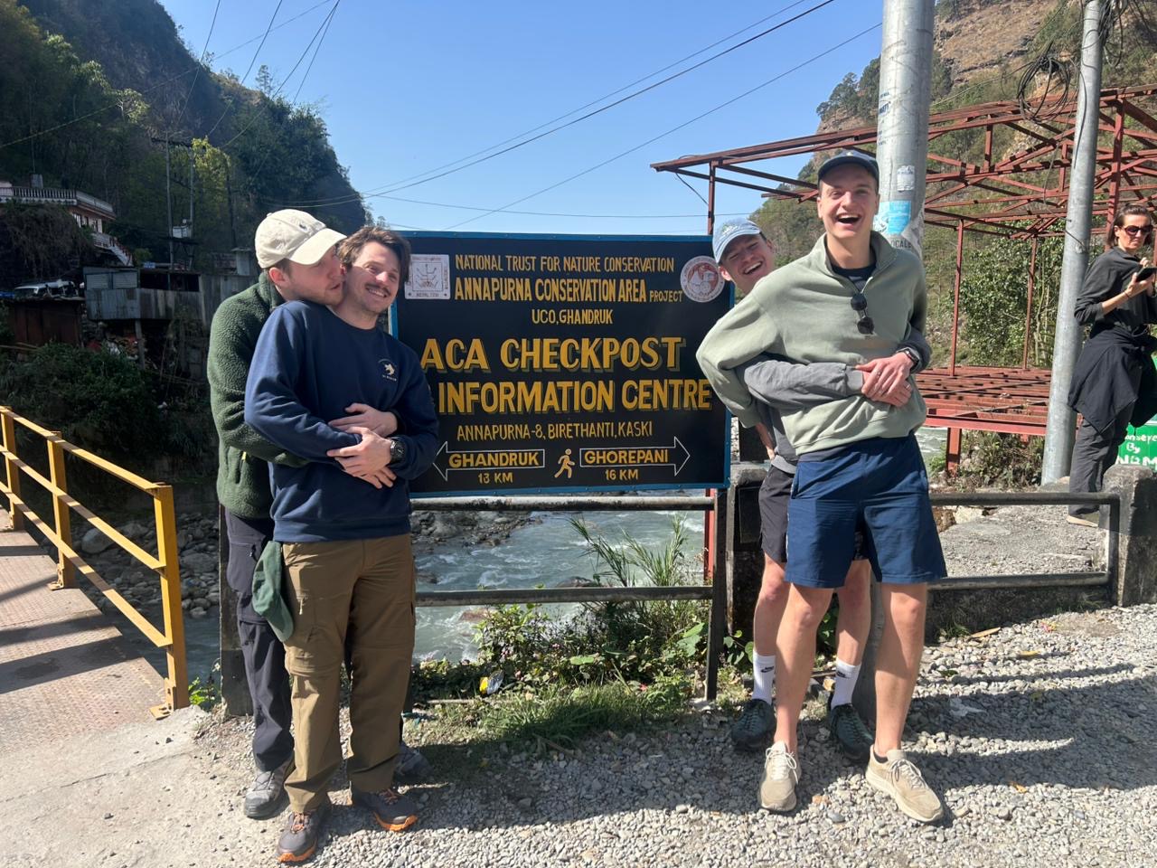
You get to experience genuine mountain culture, local hospitality, stone homes, and the rich Gurung and Magar culture of the Annapurna region by traveling via traditional villages like Ghandruk, Chhomrong, and Sinuwa.
With clearly marked trails, cosy teahouse accommodations, and fewer technical difficulties than high-altitude expeditions, the ABC trek is perfect for both beginners and seasoned hikers.
In today's article, we'll go over the Annapurna Base Camp Trek Map in detail, which will help you plan your upcoming trip.
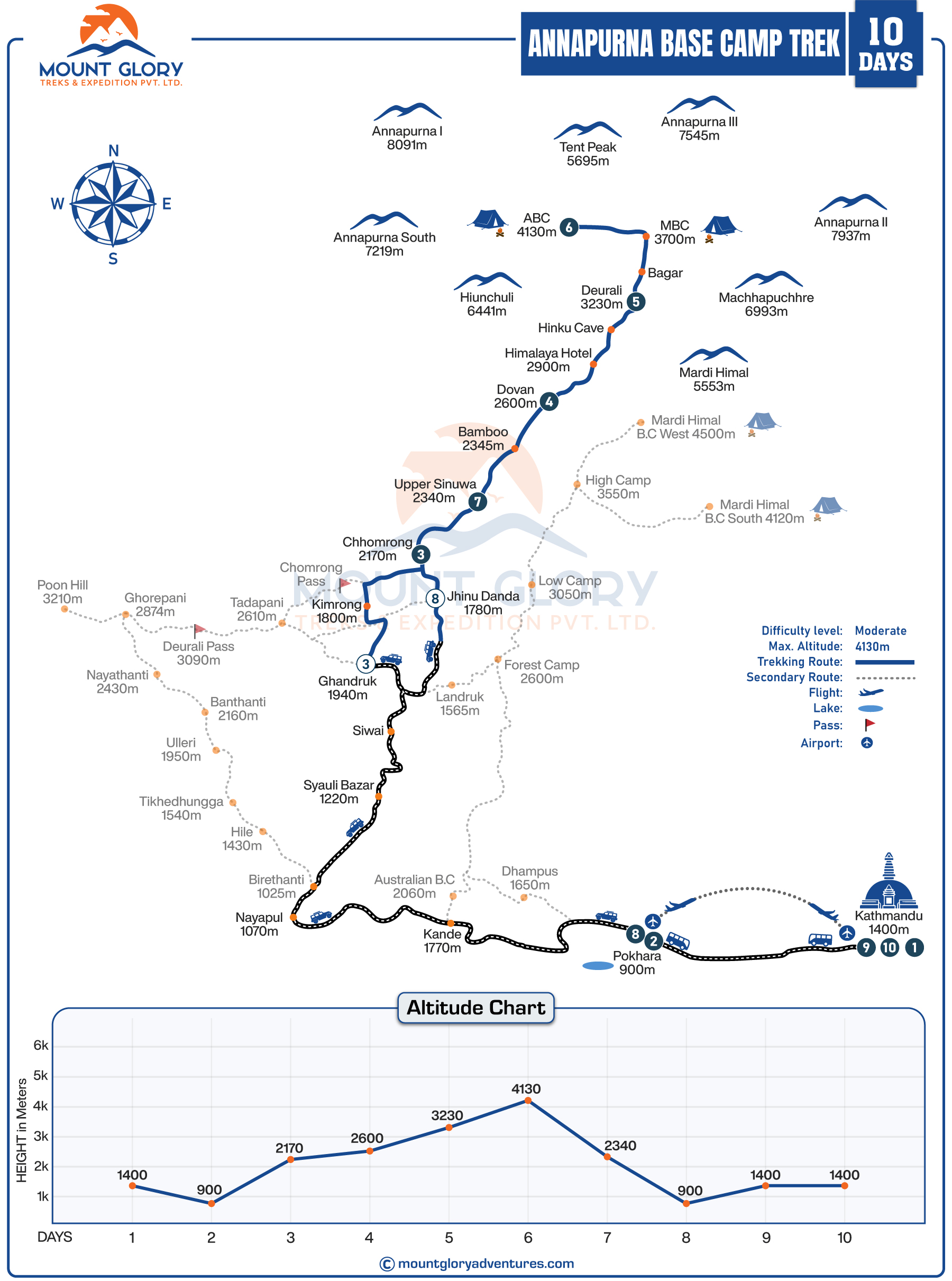
From the starting point to Annapurna Base Camp, the entire trekking route is clearly shown on the ABC Trek Map. Based on the itinerary, the standard Annapurna Base Camp Trekking map takes 9 to 15 days to finish.
Additionally, the map aids hikers in understanding the general route layout, which includes the ridgelines, valleys, and trail direction.
Travellers should comprehend a trek map because it makes it easier to plan their itinerary by highlighting important villages, teahouse stops, and places to spend the night.
Furthermore, a detailed Annapurna Base Camp Trek Map is required because the ABC route consists of multiple access points, trail variations, and altitude-sensitive sections rather than a single straight path.
Important landmarks like bamboo forests, river crossings, avalanche-prone areas, and high-altitude zones close to Machapuchare Base Camp and Annapurna Base Camp are also shown.
Mount Glory Treks created this well-structured ABC trek map to assist trekkers in smoothly navigating the route, minimising confusion, and effectively managing time.
Using the map correctly reduces the risk of altitude sickness, physical exhaustion, and itinerary delays, resulting in a safer and more enjoyable trip to Annapurna Base Camp.
For your information, we also offer a short Annapurna Base Camp Trek if you want to finish the trek faster. If you want to see more of the Annapurna region, we can also extend the ABC Trek with Poonhill and Mardi Himal. You can also choose from a variety of ABC Trek options.
Depending on road conditions and itinerary design, the Annapurna Base Camp trekking map indicates a number of potential starting points, most frequently Nayapul, Ghandruk, or Jhinu Danda.
The main trekking corridor that ascends towards Chhomrong, a crucial village designated on the map as the primary entry point into the Annapurna Sanctuary, is connected to the lower Annapurna foothills via these access points.
Moreover, the map of Annapurna indicates that, depending on route selection and side trails, the total walking distance for the Annapurna Base Camp journey typically ranges from 65 to 75 kilometres round trip.
Even though the core trekking portion can be completed in 7 to 12 days, most well-paced guided programmes, including ground transfers, are designed as a 10-day itinerary, like the standard Mount Glory Treks ABC trekking package, giving ample time for rest and acclimatization.
A wide variety of terrain is depicted in the trail layout on the Annapurna Base Camp trek map. Lower sections wind through stone staircases, terraced hillsides, and dense rhododendron forests, eventually following river valleys deeper into the mountains.
The landscape shifts to open high-altitude terrain, glacial valleys, and winding alpine trails as the route enters the Annapurna Sanctuary.
Although the trail is generally well-defined, frequent elevation gains and descents necessitate the use of a map to better understand daily effort, altitude progression, and effective time management.
Heading Towards Annapurna Base Camp 4130m from Pokhara
Annapurna Base Camp Trek Map Location
Situated in central Nepal, the Annapurna Base Camp Trek is fully contained within the country's largest protected area, the Annapurna Conservation Area (ACA).
The conservation area is a popular destination for hikers looking for both natural beauty and cultural experiences because of its breathtaking Himalayan scenery, traditional villages, and abundant biodiversity.
According to the Annapurna Base Camp itinerary, the ABC adventure travels from Nayapul, Ghandruk, or Jhinu Danda to the Annapurna Sanctuary, passing through the Modi Khola Valley and Marsyangdi River Valley.
Trekkers can enjoy expansive views of nearby ridgelines and peaks like Machhapuchhre (Fishtail, 6,993 m), Annapurna South (7,219 m), and Hiunchuli (6,441 m) along this route.
The journey passes through a number of significant areas, each of which offers distinctive geographical and cultural experiences:
Kaski District: The trailhead and the initial days of hiking through terraced farmland and subtropical forests are accessible from Pokhara and the nearby villages in lower-lying Kaski.
Gandaki District: As trekkers progress towards Chhomrong and beyond, they will encounter higher-altitude settlements with stone-built houses, traditional Gurung culture, and the first significant acclimatization points.
Manang District (Annapurna Sanctuary Approach): Before arriving at Annapurna Base Camp (4,130 m), the trail passes through open meadows, glacial moraine, and narrow valleys in high-altitude alpine terrain. This area is essential for acclimatization and beautiful views of the Annapurna massif.
From lush forests in lower regions to alpine flora close to the sanctuary, each location along the trek showcases unique architecture, regional customs, and natural landscapes.
Trekkers who follow the ABC trek map and our 10-day Mount Glory Treks itinerary will have a clear understanding of daily distances, elevation gains, and overnight stops, leading to a rewarding and safe journey through the most famous trekking region in central Nepal.
Annapurna Base Camp Elevation Chart
Annapurna Base Camp Trek Map with Elevation Profile
For safe trekking and appropriate acclimatization, it is essential to know the altitude gain along the Annapurna Base Camp trekking route. From the trailhead to Annapurna Base Camp at 4,130 metres, the hike progressively rises, enabling hikers to control their energy and lower their risk of altitude sickness.
In order to help with the planning of rest days and shorter hiking sections, important acclimatization points like Chhomrong, Dovan, and Deurali are indicated on the map.
The trek's highest point, Annapurna Base Camp (4,130 m), offers hikers breathtaking views of the Himalayas. Following the map guarantees safe pacing, adequate rest, and a greater enjoyment of the trek because daily elevation changes vary.
Key Locations and Altitudes (ABC Trek – 10 Days)
Location
Elevation in Maters
Kathmandu
1400m
Pokhara
820m
Jhinu Danda
1760m
Chhomrong
2170m
Bamboo
2340m
Dovan
2600m
Deurali
3230m
Machhapuchre
3700m
Annapurna Base Camp
4130m
ABC Distance and Daily Walking Time
The Annapurna Base Camp hike map shows that the total trekking distance, including approach routes and side trails, from the trailhead to ABC is approximately 65–75 km round trip.
However, daily distances vary, with shorter sections of 6-9 km for easier acclimatization and longer stretches of 12-14 km in high-altitude or downhill sections.
Similarly, walking times on the trek to ABC vary by terrain, ranging from 3-5 hours on moderate to forest trails to 6-7 hours on steep alpine paths or moraine sections.
Trekkers can estimate energy expenditure and pace by using the Annapurna map, which highlights uphill versus downhill sections.
Important locations like suspension bridges, river crossings, and steep stone staircases are marked, impacting daily trekking efforts and providing a clear understanding of what lies ahead.
Most significantly, the daily elevation gain is displayed, allowing hikers to efficiently schedule rest stops and acclimatization locations.
The map of Annapurna Base Camp Trekking shows long and short trekking days, allowing trekkers to adjust their pace, manage fatigue, and balance trekking with sightseeing.
You can obtain all of this information by simply using the map, which is why it is one of the most important items on your trek.
Annapurna Base Camp Trek Map for First-Time Trekkers
Beginners should focus on key markers on the Annapurna Base Camp Trekking Map, such as trailheads, villages, teahouses, river crossings, and high altitude points, rather than attempting to memorize the entire route, for a successful trip.
Similarly, the map makes it easier for hikers to pace themselves safely by helping them understand daily distances, elevation gain, and rest areas.
Underestimating altitude gain, missing acclimatization days, and disregarding terrain variations shown on the map are common mistakes made by first-time hikers.
In places with numerous trail intersections or ambiguous markers, depending only on digital maps without a certified guide may cause confusion. Using the map in conjunction with a guide allows beginners to plan daily walking hours, identify safe overnight stops, and adjust pace based on weather and altitude.
Beginners should mark key emergency exit routes and water points on the map to be prepared for unforeseen circumstances.
A well-designed ABC map provides travellers with clarity of the route, elevation changes, and daily walking distances, which directly boosts confidence on the trail and provides a clear understanding.
Trekkers can avoid needless exhaustion or hurried schedules, manage altitude gain safely, and plan realistic trekking days by being aware of the map.
Knowing a map well enables hikers to select the best route, whether using the traditional ABC method or a more condensed version, based on their level of fitness, time constraints, and prior trekking experience.
The trek map becomes an effective tool for safe navigation, acclimatization planning, and adaptable decision-making in shifting mountain conditions when paired with a knowledgeable guide.
Our 10-day Annapurna Base Camp package is carefully designed for trekkers looking for a smooth and well-organized experience. It includes proven routes, balanced walking hours, and clear elevation planning.
Mount Glory Treks ensures that trekkers follow the right map, pace, and path to Annapurna Base Camp, making the journey as rewarding as the destination.
Ready to go ABC at Pokhara with Mount Glory Treks Guide and Porters
Frequently Asked Questions
1: What does the Annapurna Base Camp trek map show? The entire trekking route, including villages, daily walking distances, elevation changes, rivers, forests, and the final approach to Annapurna Base Camp, is shown on the Annapurna Base Camp trek map. Before and during the hike, it helps hikers understand the general layout of the trail.
2: Is the Annapurna Base Camp trek map necessary for guided treks? The trek map is helpful for understanding altitude gain, visualizing daily progress, and knowing what's ahead, even with a licensed guide. It boosts self-assurance and makes it easier for hikers to follow their path.
3: How accurate is the Annapurna Base Camp trek map? Most modern ABC trek maps are highly accurate and up-to-date, particularly those provided by local trekking companies. They show current trail conditions, road access points, and major settlements along the route.
4: Can beginners follow the Annapurna Base Camp trek map easily? Yes, because the trail is well-known and clearly marked, the ABC Trek map is suitable for beginners. When used in conjunction with a guide, it becomes even easier for beginning hikers to plan and navigate daily walks.
5: What is the total distance shown on the Annapurna Base Camp trek map? Depending on the entry and exit points selected, such as Jhinu Danda or Ghandruk, the map typically indicates a round-trip trekking distance of 65 to 75 kilometres.
6: Does the trek map include elevation and altitude details? Yes, a thorough map of the Annapurna Base Camp trek includes elevation profiles, altitude markings, and important high points such as Annapurna Base Camp at 4,130 metres and Machhapuchhre Base Camp.
7: Where does the Annapurna Base Camp trek usually start on the map? Depending on road access and itinerary design, the majority of ABC trek maps indicate starting points from Nayapul, Ghandruk, or Jhinu Danda.
8: Are teahouses and villages marked on the ABC trek map? Yes, major villages and teahouse stops like Chhomrong, Dovan, Deurali, and Bamboo are prominently marked, making it easier for hikers to arrange rest stops and overnight stays.
9: Does the Annapurna Base Camp trek map show alternative routes? Trekkers can tailor their itinerary by using the route variations found on many maps, such as the shorter ABC trail options or the Ghorepani–Poon Hill extension.
10: How does the trek map help with altitude sickness prevention? Trekkers can plan safer daily walking hours, avoid rapid ascent, and pace themselves by using the map, which shows gradual elevation gain and acclimatization points.
11: Can the Annapurna Base Camp trek be done without a map? Trekking without a map is not recommended, even when accompanied by a guide. A map makes it easier to comprehend altitude, distance, and terrain, which enhances general safety and readiness.
12: Does the map show emergency exit routes? In the event of inclement weather, health problems, or the need for an early departure, comprehensive trek maps show neighbouring villages, trail intersections, and descent routes.
13: Is a digital trek map enough for the ABC trek? Although digital maps are useful, it is highly advised to carry a printed map because higher elevations have poor network coverage and limited battery charging.
14: How does the trek map help with daily time management? Trekkers can more easily plan rest periods and overnight stops by using the map to estimate walking hours by comparing distance, elevation gain, and terrain type.
15: Where can trekkers get a reliable Annapurna Base Camp trek map? Experienced local operators like Mount Glory Treks, who create maps based on current trails, actual trekking conditions, and sensible itinerary planning, offer the most trustworthy maps.
Born and raised in the Mountainous village of Gorkha Nepal. Mr. Pandey is a successful tour leader and a very active social worker contributing a lot to the welfare of society. Mr, Pandey belongs to a very humble background and has started his career as a junior staff in a much-reputed company in Nepal. Mr. Pandey's family background is engaged in the tourism sector for an extended period. After spending many years in research and the drawbacks of tourism development.
Due to his great passion and enthusiasm for the trekking and tourism sector, he started his tour career with many expert teams. He intends to bring revolution to the tourism sector by offering luxurious services and accommodations to travelers at a minimum price. With the Motto of Travellers, satisfaction is my passion. He has been helping many travelers with traveling.


 25 reviews