15 Days Island Peak Climbing Map Details By Mount Glory Treks
The Island Peak, also called Imja Tse, is a 6,189-meter trekking peak near Lhotse and Ama Dablam in the tranquil Imja Valley of Everest.
As one of Nepal's most accessible 6000-metre peaks, Island Peak is a popular option for hikers transitioning from high-altitude trekking to simple mountaineering.
Understanding the route to Island Peak is crucial because, despite being labelled as an entry-level peak, the climb involves glacier travel, fixed ropes, snow slopes, and a steep summit ridge.
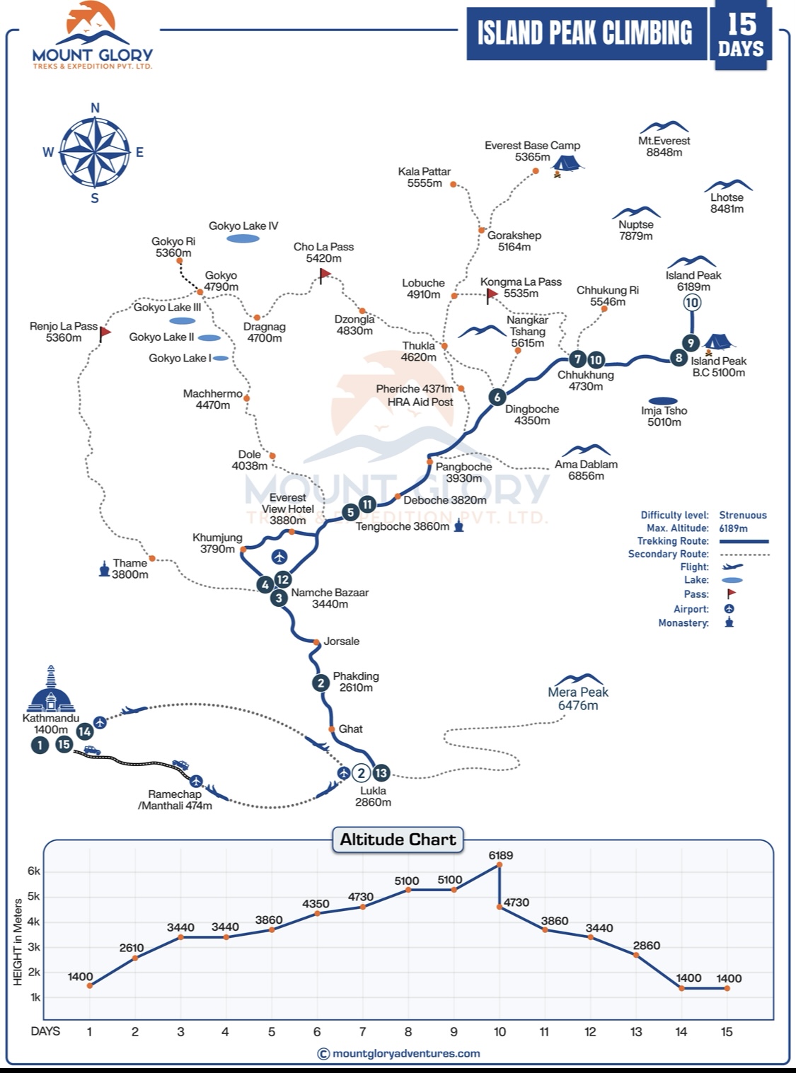
Climbers can see the entire route from Lukla to the summit, including the trekking sections, base camp, high camp, and summit push routes, with the help of a comprehensive Island Peak climbing map.
The map shows elevation gain at each stage, allowing climbers to accurately assess altitude exposure and plan acclimatisation days.
Daily progress is easier to monitor because important locations like Namche Bazaar, Dingboche, Chhukung, Island Peak Base Camp, and High Camp are clearly marked.
Technical areas, such as glacier crossings, crevasse zones, fixed rope areas, and steep snow or ice slopes close to the summit, are highlighted on a climbing map.
Likewise, climbers can better prepare both physically and mentally for changing conditions by being aware of the different types of terrain, such as forest trails, alpine paths, moraine sections, glaciers, and snowfields.
From a planning standpoint, the map facilitates route familiarisation, practical time management, and backup plans in the event of inclement weather or acclimatisation problems.
The Island Peak Climbing Map assists climbers in identifying safe campsites, descent routes, and emergency exit points, which is especially useful in high-altitude environments.
On both trekking and climbing days, the map enhances navigation accuracy, lowers the chance of making incorrect turns, and boosts confidence when paired with a guide's expertise or GPS equipment.
The gradual approach, acclimatisation strategy, and technical progression necessary for a safe and successful ascent are all reflected in the Island Peak climbing map. Weather, terrain difficulty, and altitude gain all affect the summit push, rest days, and route design.
Mount Glory Treks takes a traditional Island Peak climbing route that starts with an Everest region trek, ends with a technically supported summit climb, and then returns via the same trail.
This route, when viewed on a climbing map, clearly shows the progressive altitude gain, acclimatisation pauses, base camp placement, and technical summit section, assisting climbers in understanding both the trekking and mountaineering phases of Island Peak.
15 Days Island Peak Climbing Itinerary
Day 01: Arrival in Kathmandu and pre-trip meeting.
Day 02: Fly from Kathmandu to Lukla and trek to Phakding.
Day 03: Trek from Phakding to Namche Bazaar.
Day 04: Acclimatisation day at Namche Bazaar.
Day 05: Trek from Namche Bazaar to Tengboche.
Day 06: Trek from Tengboche to Dingboche.
Day 07: Trek from Dingboche to Chhukung.
Day 08: Trek from Chhukung to Island Peak Base Camp.
Day 09: Ascend from Base Camp to High Camp, following glacial and moraine sections.
Day 10: Summit Island Peak (6,189 m) and descend to Chhukung.
Day 11: Trek back from Chhukung to Pangboche or Tengboche.
Day 12: Trek to Namche Bazaar.
Day 13: Trek from Namche Bazaar to Lukla.
Day 14: Fly from Lukla to Kathmandu.
Day 15: Final Departure.
18 Days Island Peak Climbing With Everest Base Camp Trek
Day 1: Arrival in Kathmandu and pre-trip meeting.
Day 2: Flight from Kathmandu/Manthali to Lukla. Flight time: Approx 40 min from KTM/20 min from Manthali. Trek to Phakding (2,650 m).3-4 hours hike
Day 3: Trek from Phakding to Namche Bazaar (3,440 m). Trek time: Approx. 6 hrs.
Day 4: Rest day and Acclimatization at Namche Bazaar.
Day 5: Trek from Namche to Tengboche (3,855 m). Trek time: Approx. 5 hrs.
Day 6: Trek from Tengboche to Dingboche (4,360 m). Trek time: Approx. 5 hrs.
Day 7: Trek from Dingboche to Lobuche (4,930 m). Trek time: Approx. 5 hrs.
Day 8: Trek from Lobuche to EBC (5,364 m) and back to Gorak Shep (5,185 m). Trek time: Approx. 6-8 hrs.
Day 9: Hike to Kala Patthar (5,555m) Viewpoint, trek to Gorakshep, then to Chhukung (4,730m). Trek time: Approx. 5 hrs.
Day 10: Rest day to relax and acclimatize at Chhukung
Day 11: Trek from Chhukung to Island Peak Base Camp (5000m). Trek time: Approx. 4 hrs.
Day 12: Summit Island Peak (6189m) & return to Chhukung. Trek time: Approx. 10-11 hrs.
Day 13: Leisure Day for Bad weather.
Day 14: Trek from Chhukung to Tengboche (3,870m). Trek time: Approx. 6 hrs.
Day 15: Trek from Tengboche to Namche Bazaar (3,441m). Trek time: Approx. 6 hrs.
Day 16: Trek from Namche Bazaar to Lukla (2850m). Trek time: Approx. 6 hrs.
Day 17: Fly back to Kathmandu/ Manthali from Lukla. Flight time: Approx. 40 min for KTM/20 min for Manthali. Drive time: Approx. 5 hrs from Manthali to KTM
Day 18: Final Departure.
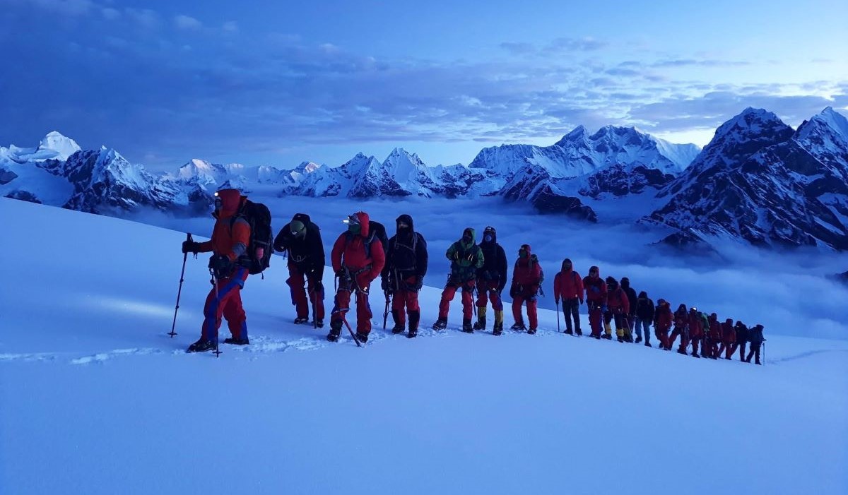
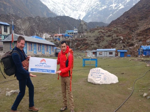
Mount Glory Treks Climbing team are on the way to Island Peak 6189m
Island Peak Climbing Map Route
Starting with a flight from Kathmandu to Lukla, the Island Peak climbing map route follows the traditional Everest trekking corridor, passing through Monjo, Namche Bazaar, Tengboche, Dingboche, and Chhukung before arriving at Island Peak Base Camp and High Camp.
A well-designed map of Island Peak climbing depicts the entire journey in one view, including the trekking approach, the technical climbing section leading to the summit, and the return along the same trail.
The map's early sections, which offer gradual acclimatisation and cultural exposure, feature Sherpa villages, suspension bridges, and forested trails.
Increasing elevation, broader valleys, and famous Himalayan landscapes, such as views of Ama Dablam and Lhotse, can be seen in the midsection between Namche and Dingboche. The terrain also becomes more open and alpine.
On the Island Peak map, the route after Chhukung clearly changes from hiking to mountaineering, moving from trekking paths to glacial terrain and moraine.
With steep snow slopes, fixed rope sections, and the final exposed ridge leading to the summit, climbing maps clearly depict the route from Base Camp to High Camp and the summit.
By mapping elevation gain, terrain changes, and key camps, the route map assists climbers in determining where the trek ends, where technical climbing begins, and which sections require the most physical and mental effort.
Sections of Island Peak Climbing Map
Starting Point on the Map – Lukla (2,860 m): Lukla is the starting point for climbing Island Peak and the entrance to the Everest region. The flight path from Kathmandu to Lukla is depicted on the map, giving the trip ahead some context. Planning the trek requires an understanding of Lukla's high-altitude airstrip, erratic weather, and early morning flight schedules.
Lukla to Namche Bazaar: Along this section, the map shows river crossings, trails through forests, and gradual ascents. Additionally, it designates rest areas, suspension bridges, and villages. The map aids hikers in visualising daily distances and altitude gain for a safe approach, and Namche Bazaar is the main acclimatisation point.
Namche Bazaar to Tengboche: Steeper slopes, open alpine valleys, and expansive views of Ama Dablam and neighbouring peaks can be seen in this section. One of the area's cultural highlights, the Tengboche Monastery, is marked on the map, which also aids climbers in scheduling stops at vantage points and water sources.
Tengboche to Dingboche: The map illustrates the change from woodlands to high alpine terrain as hikers ascend. Along the way, river crossings, small towns, and lodges are marked on the map, and contour lines show the rising gradient.
Dingboche to Chhukung: The intermediate high camp area is reached by the route from Dingboche to Chhukung. Climbers can better understand their proximity to Island Peak Base Camp and make plans for acclimatisation by using the map, which shows the expansion of glacial valleys and rocky terrain.
Chhukung to Island Peak Base Camp: In this section, the high mountain environment is approached. Moraine fields, glacial streams, and uneven terrain are depicted on the map, which makes it easy to see how hiking trails lead to Base Camp at 5,087 metres, where tents and other necessary camp amenities are set up.
Island Peak Base Camp (5,087 m): On the map, Base Camp is prominently marked with tent spaces, water sources, and routes leading to High Camp. Before the summit push, climbers can better manage their gear, sleeping arrangements, and daily activities by being aware of the layout.
Island Peak High Camp (5,600 m): The staging area for the summit attempt is High Camp, which is situated close to the glacier. In order to help climbers visualise the final climb safely, the map displays turnaround points, fixed rope segments, and tent placement.
Summit Ridge & Technical Section: Along the summit ridge, the map indicates fixed rope lines, crevasse zones, and steep slopes. Climbers can plan timing, pace, and safety precautions for the push to the 6,189-metre summit of Island Peak by using contour lines that show gradient and exposure.
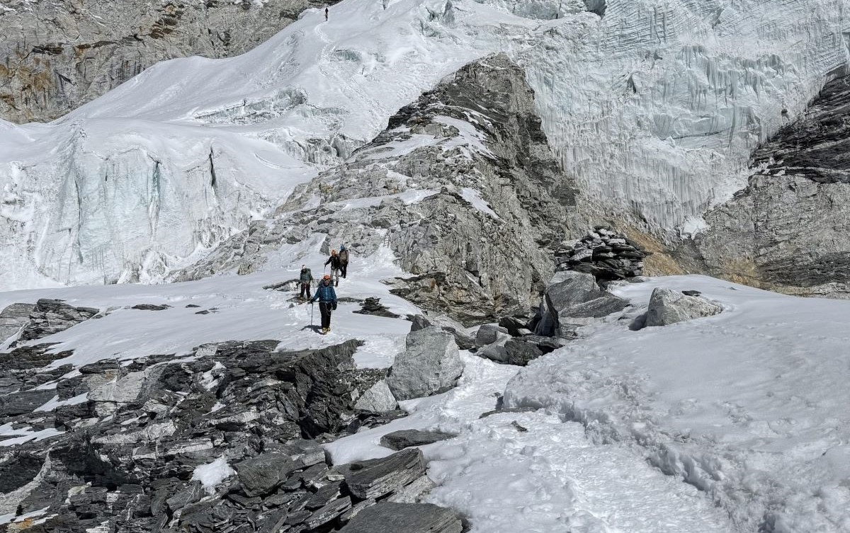
Heading towards Island Peak Base Camp from Chukkung
Elevation Profile on the Island Peak Map
A climbing map's elevation profile helps climbers plan their pace and acclimatisation by displaying the altitude gain, trail difficulty, and daily distances.
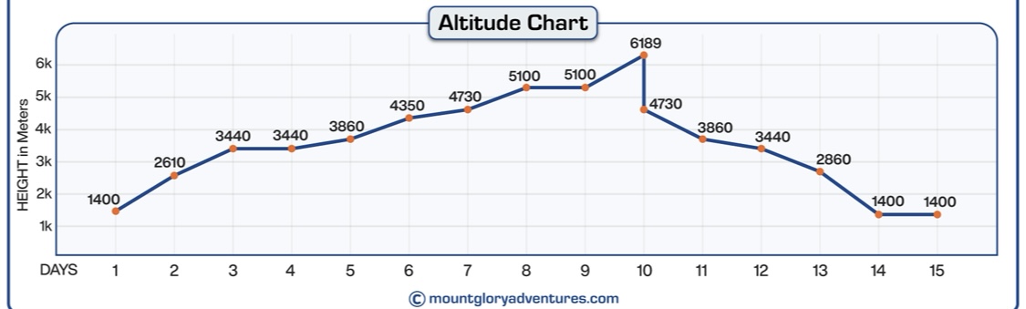
Lukla (2,860 m), Namche Bazaar (3,440 m), Tengboche (3,860 m), Dingboche (4,410 m), Chhukung (4,730 m), Base Camp (5,087 m), High Camp (~5,600 m), and Summit (6,189 m) are important elevation points along the route.
By monitoring their daily elevation gain, climbers can avoid altitude sickness, effectively plan rest days, and prepare for technical sections near the summit.
Island Peak Climbing 15 Days Elevation Chart
In Conclusion
Every hiker and climber needs the Island Peak climbing map in order to visualise the route, comprehend altitude changes, and locate technical areas. On both trekking and summit days, studying the map prior to departure enhances safety, navigation, and general confidence.
You can properly plan acclimatisation and make wise decisions on the trail by becoming familiar with camps, important landmarks, and daily elevation gain.
Guided trips with Mount Glory Treks offer professional route knowledge, map guidance, and safe summit preparation for those in need of additional assistance, guaranteeing a seamless and well-planned Island Peak experience. We also organize three popular peak climbs in the Everest Region, including Mera Peak Climbing, Lobuche Peak Climbing, and Mera Peak Climbing With EBC Trek. You can choose as per your time, budget, and climbing availability.
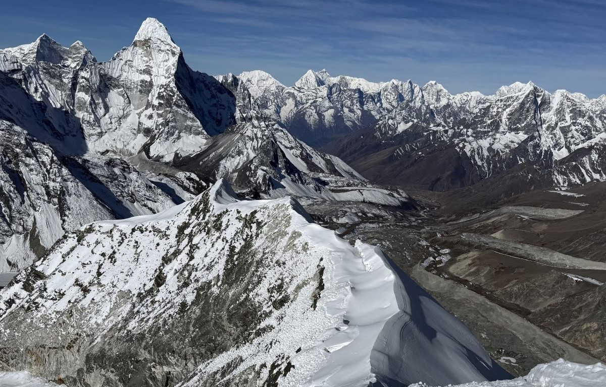
Way to Island Peak 6189m with Everest Himalayan Range
Frequently Asked Questions
1: What is the Island Peak climbing map and why is it important? The entire route from Lukla to the summit, including Base Camp, High Camp, and technical sections, is depicted on the Island Peak climbing map. It is crucial for visualising fixed rope sections, glacier areas, terrain type, and altitude gain. By using the map to plan daily distances, rest days, and summit timing, climbers can reduce their risk of getting lost or encountering unanticipated issues.
2: Where does the Island Peak trek start and end according to the map? In order to reach the 6,189-meter summit, the route begins at Lukla (2,860 metres) and travels along the Everest region trekking corridor through Namche Bazaar, Tengboche, Dingboche, Chhukung, Base Camp, and High Camp. The return trail via the same route is also depicted on the map, which is essential for safely planning the descent.
3: How does the map show acclimatisation points? On the map, important locations like Namche Bazaar, Dingboche, and Chhukung are indicated along with elevation information. This aids climbers in planning rest days and acclimatisation hikes, which are essential for avoiding altitude sickness during the high-altitude portions close to Base and High Camp.
4: Can the Island Peak map help identify technical sections of the climb? Yes, the map identifies glaciers, moraine fields, fixed rope segments, steep snow slopes, and crevasse-prone terrain. Climbers can prepare essential equipment, such as crampons, ice axes, and harnesses, and know where extra caution is needed by reading these sections beforehand.
5: How accurate is the elevation information on the Island Peak map? Key locations on maps usually include Lukla (2,860 m), Namche (3,440 m), Tengboche (3,860 m), Dingboche (4,410 m), Chhukung (4,730 m), Base Camp (5,087 m), High Camp (~5,600 m), and Summit (6,189 m). These elevations aid in estimating the amount of time required for safe acclimatisation as well as the daily altitude gain.
6: Does the map include campsites and water sources? Yes, Base Camp, High Camp, appropriate tent locations, and adjacent water sources are indicated on Island Peak maps. Climbers can efficiently plan overnight stays and manage resources like food and fuel for melting water by being aware of these locations.
7: Can I use a digital map for Island Peak climbing? The physical map can be enhanced by digital maps and GPS applications that display elevation, distance, and offline routes. However, a physical map is highly advised for safe navigation and backup due to the limited mobile coverage in the Everest region.
8: How does the map help in emergency situations? The map helps with evacuation or descent route planning by displaying alternate routes, camps, and neighbouring villages. In the event of illness, injury, or inclement weather, it also facilitates communication between climbers and guides.
9: Is it necessary to study the map before the climb? Of course. Examining the map in advance boosts self-assurance, lowers anxiety, and enhances trail decision-making. A safer and more effective ascent is ensured by knowledge of the terrain, elevation changes, and glacier sections.
10: Can guided tours help me use the Island Peak climbing map more effectively? Yes, expert guides offer advice on route selection, map interpretation, and technical section tips. While relying on expert knowledge for map reading and high-altitude decision-making, guided trips improve safety, facilitate navigation, and free up climbers to concentrate on the ascent.
Born and raised in the Mountainous village of Gorkha Nepal. Mr. Pandey is a successful tour leader and a very active social worker contributing a lot to the welfare of society. Mr, Pandey belongs to a very humble background and has started his career as a junior staff in a much-reputed company in Nepal. Mr. Pandey's family background is engaged in the tourism sector for an extended period. After spending many years in research and the drawbacks of tourism development.
Due to his great passion and enthusiasm for the trekking and tourism sector, he started his tour career with many expert teams. He intends to bring revolution to the tourism sector by offering luxurious services and accommodations to travelers at a minimum price. With the Motto of Travellers, satisfaction is my passion. He has been helping many travelers with traveling.


.webp)