The Upper Mustang Trek in Nepal is a one-of-a-kind Himalayan trip that takes you into a restricted area in the remote trans-Himalayan region of northwestern Nepal, which borders Tibet.
This challenging trek is in the rain shadow of the Annapurna and Dhaulagiri ranges, which means it has a dry, desert-like landscape that is different from any other trekking area in Nepal.
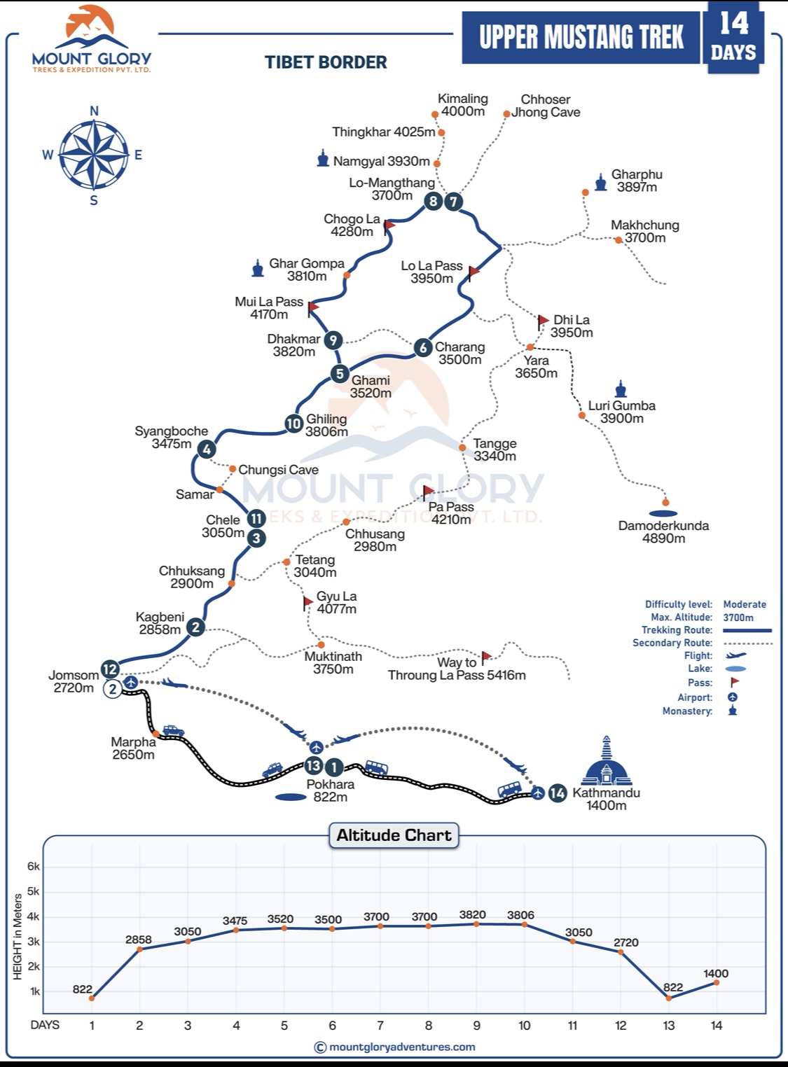
Because it is a restricted area and has a unique geography, you need to use a Detailed Upper Mustang Trek map to understand the route layout, entry points, and overall flow of the trek.
An accurate Upper Mustang Trekking Route Map shows trekkers how the journey begins in Jomsom and Kagbeni, follows the Kali Gandaki Valley, and gradually ascends through traditional Mustang villages to Lo Manthang (3,800 m), the historic walled city known as the "Last Forbidden Kingdom".
Furthermore, the trekking map highlights key locations, altitude changes, and the loop-style return route, making it an invaluable tool for both planning and trail awareness.
In this guide, you will learn about the Lo Manthang trek map and the Mustang Nepal route in detail, including how the trail is laid out, where the major stopovers are, and how geography and terrain influence the overall trekking experience. This will provide you with a clear and practical understanding of the route before you begin your Upper Mustang trek.
The Upper Mustang Trekking package by Mount Glory Treks itinerary is 14 days long, beginning in Kathmandu and covering all of the highlights of the Upper Mustang trek. This is a standard tour package suitable for anyone looking to conquer the restricted Mustang trekking area.
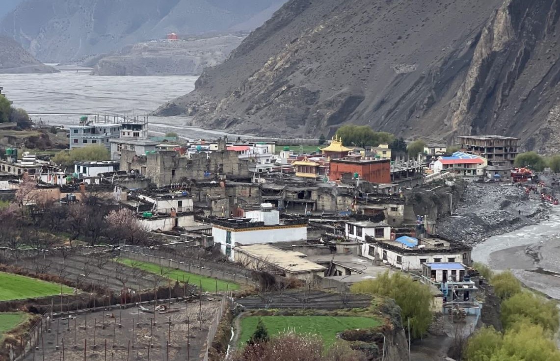
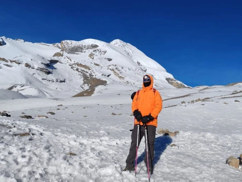
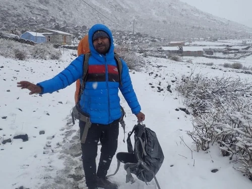
Trekkers are Enjoying the Beautiful Landscape of Upper Mustang Trekking Area
The Upper Mustang Trek route map depicts a carefully planned journey through Nepal's restricted trans-Himalayan region, beginning in the lower Himalayas and gradually moving into the dry, culturally rich landscapes of Mustang.
Starting the standard route with a trip from Kathmandu to Pokhara, followed by a beautiful flight to Jomsom (2,720 m). The trek goes on from Jomsom to Kagbeni (2,810 m), which is the official checkpoint and entrance to the restricted Upper Mustang area.
The trekking trail begins in Kagbeni and follows the Kali Gandaki Valley, gradually ascending through ancient villages, barren cliffs, and traditional settlements. Moreover, the main trekking section of the Upper Mustang trekking route map contains the following key route progression:
Route: Kagbeni to Chele, Syangboche to Ghami, Charang to Lo Manthang (3,800 m).
Return route: Lo Manthang to Dhakmar, Ghiling, Chele, and Jomsom.
This structure makes a loop trekking route, which is one of the things that makes the Upper Mustang journey special. Instead of going back the same way, trekkers see a different set of landscapes and villages on the way back, which gives them more variety in geography and culture.
The terrain along the Mustang route is very different from other trekking areas in Nepal. The Mustang route map shows a big change into a desert environment that crosses the Himalayas.
This transformation is shown by:
Dry, arid valleys and wind-shaped landscapes
Deep river gorges along the Kali Gandaki corridor
Ancient caves carved into cliffs
Wide open plateaus and eroded rock formations
Traditional Tibetan-style settlements with monasteries and chortens
The Lo Manthang trek map also shows that the area is in a rain shadow behind the Annapurna and Dhaulagiri ranges, which is another important geographical feature.
Usually, this natural barrier keeps monsoon rains from falling, which makes for dry, stable trekking conditions. This makes Upper Mustang one of the few Himalayan areas where you can trek even when the weather isn't great.
Detailed 14 Day Upper Mustang Trek Map Itinerary
The Upper Mustang Trek itinerary map shows a well-planned 14-day trip that will help you gain altitude slowly, get used to the high altitude, and see all of the restricted Mustang area. The route ascends to the historic walled city of Lo Manthang (3,800 m) by driving, flying, and trekking through the Kali Gandaki Valley.
Day 1: Drive from Kathmandu to Pokhara
The capital is connected to Pokhara, the starting point for the Annapurna and Mustang treks, by a picturesque drive along the Prithvi Highway. This day aids in getting ready for the journey that lies ahead.
Day 2: Fly to Jomsom and Trek to Kagbeni
The Upper Mustang restricted area's official entry point, Kagbeni, is reached by trekking after a brief mountain flight to Jomsom (2,720 m). Moreover, the traditional village of Kagbeni is situated at the confluence of the Kali Gandaki River.
Day 3: Trek from Kagbeni to Chele
The trek formally enters the Upper Mustang region, which is off-limits. Likewise, the trail slowly climbs through dry areas, which is where the trans-Himalayan terrain starts.
Day 4: Trek from Chele to Syangboche
A hard part with a slow rise in height. The route goes through the village of Samar and old cave systems, giving you a look at Mustang's cultural history.
Day 5: Trek from Syangboche to Ghami
The trail goes through dry valleys, mani walls, and red cliffs before ending in Ghami, which is one of the biggest villages in Upper Mustang.
Day 6: Trek from Ghami to Charang
A shorter hiking day through open plateaus and traditional landscapes. Charang is renowned for its monasteries and fortress-like structures.
Day 7: Trek from Charang to Lo Manthang
The most anticipated day of the trek is the entry into Lo Manthang (3,800 m), Upper Mustang's walled capital known for its royal palace, monasteries, and ancient Tibetan culture.
Day 8: Explore Lo Manthang
A full day of rest and exploration in Lo Manthang, including visits to monasteries, caves, local settlements, and cultural landmarks.
Day 9: Trek to Dhakmar
The route passes through breathtaking scenery, including the famous red cliffs of Dhakmar and Ghar Gompa, one of the region's oldest monasteries.
Day 10: Trek to Ghiling
A descent along ancient trade routes leads to Ghiling, a peaceful village surrounded by traditional Mustang terrain.
Day 11: Trek back to Chele
The return journey begins, taking a different scenic route with varying views of the Mustang landscape.
Day 12: Trek to Jomsom
A long descent back to Jomsom marks the end of the Upper Mustang trekking route.
Day 13: Fly to Pokhara
Trekkers return to Pokhara for some rest and relaxation after a short scenic flight.
Day 14: Drive to Kathmandu
The final drive back to Kathmandu concludes the Upper Mustang Trek map itinerary experience.
This day-by-day trekking route map for Upper Mustang makes sure that you get used to the area, learn about its culture, and see all of it in a loop. It's one of Nepal's most restricted and unique Himalayan areas.
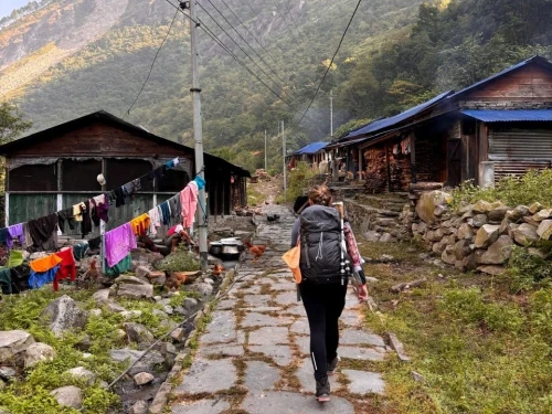
Kagbeni Village
Key Locations on Upper Mustang Trek Map
The Upper Mustang Trekking map in Nepal shows a number of important places that are important for finding your way, climbing higher, and learning about the culture. Knowing about these stops helps hikers plan their trip better and makes sure they get used to the altitude during the whole trek.
Jomsom (2,720 m)
The main way to get to the Mustang region is through Jomsom, which you can get to by flying from Pokhara. It is where the trek begins and ends, and it has basic amenities, places to stay, and internet access. Jomsom is an important logistical hub on the Upper Mustang trekking route map. Trekkers get ready there before they start the trail.
Kagbeni (2,810 m)
Kagbeni is the official checkpoint for getting into the restricted Upper Mustang region. It is located along the Kali Gandaki River. Permits are checked here, making it a crucial stop on the Mustang trekking route. It also serves as the first acclimatisation stop because the altitude rises slowly from Jomsom.
Chele & Syangboche (3,000–3,800 m)
These villages mark the border between the lower and upper Mustang regions. The Upper Mustang trek map shows that this part of the trail goes up in elevation and the terrain changes. It helps people get used to the higher altitudes by letting them get used to the lower ones first.
Ghami & Charang (3,500 m)
Ghami and Charang are two of the biggest and most important villages along the way in terms of culture. These places have monasteries, mani walls, and traditional villages. On the Lo Manthang trek map, they are important mid-route stops for navigation, giving you a chance to rest, get more supplies, and get used to the higher altitude.
Lo Manthang (3,800 m)
The Upper Mustang Trek's main attraction is Lo Manthang. This old walled city is the cultural and historical heart of the area. This is the highest point on the standard itinerary, so it's a very important place for both acclimatisation and exploration.
Dhakmar (3,820 m)
One of the most visually interesting places on the way back is Dhakmar, which has beautiful red cliffs and rough terrain. The Upper Mustang route map shows a different way down and gives you a different view of the area's geography.
Road Access & Trekking Trail in the Upper Mustang Trekking Map
The Mustang Trekking map shows a mix of roads that can be driven on and traditional trekking trails, especially in the lower parts of the Mustang region. Parts of the road from Jomsom to Kagbeni and beyond to Upper Mustang are now open to jeeps, which has changed how the trekking trail is set up.
Modern maps of the Upper Mustang trekking route clearly show these parts of the trail that are also roads, making it easy for trekkers to see where the trail crosses vehicle tracks. You can still have the classic trekking experience by taking different paths above the road. These paths offer better views, quieter routes, and a more authentic cultural journey through traditional Mustang villages.
As the route gets closer to Lo Manthang, it goes deeper into the restricted area. The trail becomes clearer and less affected by roads, keeping the feel of a remote Himalayan trek. The map also shows trail detours, ridge paths, and off-road sections that make walking easier and give you a better view.
For planning daily trekking distances, avoiding road-heavy areas, and picking the best walking routes, it's important to use an updated Upper Mustang Trek map.
The map makes it easier to find your way around, helps you choose the best routes, and makes your trekking experience in Mustang, Nepal, more immersive, whether you're going alone with a guide or as part of a package.
Upper Mustang Trek Altitude
If you want to plan a safe and well-paced trip through this restricted part of the Himalayas, you need to know the elevation profile of the Upper Mustang Trek.
Unlike high-altitude treks like the Everest Base Camp Trek or the Annapurna Circuit, the Upper Mustang Trek has a moderate altitude, with gradual elevation gain and fewer extreme altitude risks. However, proper acclimatisation is still required as the trek ascends to Lo Manthang (3,800 m).
The Upper Mustang Trek map visualises daily altitude changes, allowing trekkers to better manage their walking hours, rest stops, and overall energy levels.
Because the majority of the route after Kagbeni remains above 3,000 metres, maintaining a consistent pace and staying hydrated is essential for a comfortable trekking experience.
Although the Upper Mustang route does not include extremely high passes, the constant elevation above 3,000 metres necessitates a gradual ascent profile.
The restricted area hike itinerary is intended to promote natural acclimatisation, particularly between Kagbeni and Lo Manthang.
Locations
Elevation (Meters)
Kathmandu
1400m
Pokhara
820m
Jomsom
2720m
Kagbeni
2810m
Chele
3050m
Syangboche
3800m
Ghami
3520m
Charang
3560m
Lo Mangthang
3800m
Dhakmar
3820m
Ghiling
3570m
Understanding Terrain Through the Upper Mustang Trek Map
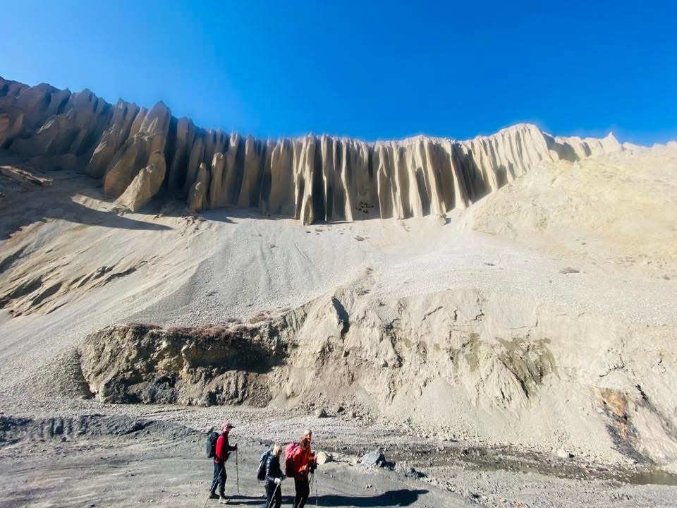
The Mustang Trekking map accurately depicts the region's unique terrain, which differs greatly from the green hills of other trekking areas in Nepal. Located in the rain shadow of the Annapurna and Dhaulagiri Ranges, the landscape is primarily dry, arid, and desert-like, with little rainfall throughout the year.
According to the Upper Mustang trekking route map, the trail passes through wide open valleys and exposed plateaus with strong winds, particularly in the afternoon. Erosion has shaped the terrain, resulting in dramatic cliffs, narrow gorges, and layered rock formations that define the Mustang region.
One of the most notable features on the map is the presence of ancient cave systems carved into high cliffs, which were previously used for meditation, shelter, and even burial practices.
Trekkers pass through traditional Tibetan-style villages and monasteries along the way, highlighting the region's strong Buddhist cultural ties.
The Lo Manthang trek map makes it easier to see the distance between settlements, which is important in this remote region with dispersed villages.
It also depicts how the terrain gradually transitions from river valleys to higher dry plateaus, allowing trekkers to better understand daily walking conditions and plan accordingly.
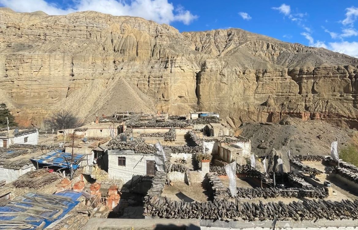
Natural Landscape of Upper Mustang Area of Nepal "Forbidden Kingdom of Nepal"
Using the Upper Mustang Trek Map Tips
Using an Upper Mustang Trek map correctly can make your trek much better by helping you find your way, plan your trip, and be aware of the whole route. The trail is easy to follow, but the remote terrain and weather make it important to use the map correctly.
Combine the map with local guide knowledge: Even with a detailed Upper Mustang trekking route map, trekking with a licensed guide is required in this restricted area. Guides provide real-time information on trail conditions, weather, and cultural routes that maps cannot provide.
Track your daily trekking route: Use the map to understand each day's trail section, including starting and finishing points like Kagbeni, Ghami, and Lo Manthang. This promotes a clear sense of direction and daily progress.
Monitor elevation and altitude gain: An Upper Mustang altitude map allows you to see gradual elevation changes, which aids in proper acclimatisation and prevent unnecessary fatigue during the trek.
Plan distances and walking hours: The map allows you to estimate the distance between villages and calculate approximate trekking hours, which is useful for pacing and energy management.
Carry an offline map or GPS backup: Because mobile networks are unreliable in the Mustang region, having an offline Mustang Nepal route map or GPS app allows you to navigate even when there is no internet connection.
Be prepared for terrain and weather challenges: Although the trails are mostly clear, the Upper Mustang terrain includes windy valleys, exposed ridges, and dry paths. The map makes it easier to identify such sections and prepare accordingly.
Conclusion
Planning the Upper Mustang Trek in Nepal with a thorough understanding of the route, terrain, and altitude is critical for a safe and well-managed journey through this restricted Himalayan region.
Although the trek does not reach extreme altitudes, the remote location, dry terrain, and long trekking distances necessitate careful planning and understanding of the overall route structure.
A detailed map of the Upper Mustang Trek helps trekkers understand the daily route, elevation flow, key villages, and loop trail system. This lets them better manage their pace and energy.
It also makes it easier to find your way around, especially in wide open spaces where trails can look the same because of the desert-like environment.
While the map is an excellent planning tool, combining it with the knowledge of a licensed local guide ensures safe navigation, proper acclimatisation, and a better cultural understanding of the Mustang region. Guides also help with permits, logistics, and making real-time decisions based on weather and trail conditions.
Trekking with Mount Glory Treks ensures professional planning, balanced itineraries, and consistent support throughout the journey.
With proper preparation and guidance, the Upper Mustang trekking route provides a unique and enriching experience through one of Nepal's most culturally preserved and geographically distinct regions.
Frequently Asked Questions
1: What is the Upper Mustang Trek map, and why is it important? An Upper Mustang Trek map is more than just a route diagram; it helps you understand the entire trekking route, including daily distances, altitude changes, and key villages such as Kagbeni and Lo Manthang. Using a map allows trekkers to better plan, manage energy levels, and see how their journey progresses through this restricted Himalayan region.
2: Where does the Upper Mustang Trek route start and end? Most people start the Upper Mustang trekking route by going from Kathmandu to Pokhara and then flying to Jomsom. The walk officially starts in Kagbeni and goes in a loop through Upper Mustang before ending in Jomsom. Having a map of this route can help you understand the big picture of travel and logistics.
3: How difficult is the Upper Mustang Trek route? The trek is thought to be of moderate difficulty, but the real challenge comes from long days of walking, dry ground, and windy weather, not from being at a high altitude. Before starting their trek, trekkers should look over the Upper Mustang route map to get ready for the daily distances and changes in terrain.
4: What is the maximum altitude shown on the Upper Mustang Trek map? The highest point on the standard Lo Manthang trek map is about 3,800 metres, which is not too high compared to other treks in the Himalayas. But because most of the hike is above 3,000 m, it's still important to pace yourself and get used to the altitude.
5: Is the Upper Mustang Trek a loop or a straight route? The Upper Mustang trekking route map shows a loop-style itinerary, which means that trekkers take a different path back instead of the same one. This gives you a wider range of landscapes and a better look at the area.
6: Do I need a guide to follow the Upper Mustang Trek map? Yes, the Upper Mustang area is off-limits, so you must go with a licenced guide and a registered agency. A map can help you figure out the way, but a guide can keep you safe, handle permits, and make the whole trekking experience better.
7: What kind of terrain is shown on the Upper Mustang Trek map? The map shows a desert landscape that crosses the Himalayas, with dry valleys, rocky trails, cliffs, and old cave formations. Before going on a trek, it's important to know what the terrain will be like so you can get ready for wind, sun, and long stretches of open walking.
8: Can I trek Upper Mustang during the monsoon season? Yes, one of the Mustang, Nepal, route's unique benefits is that it is in the rain shadow of the Himalayas. The Upper Mustang Trek map shows that the area doesn't get much rain, so it's a good place to hike even during the monsoon season.
9: How long does it take to complete the Upper Mustang Trek? Most Upper Mustang trek plans last between 12 and 14 days, depending on the route and how long it takes to get used to the altitude. Looking at the map helps you see how the days are set up and how far apart things are.
10: How does the Upper Mustang Trek map help with planning? A detailed Upper Mustang trekking map lets trekkers plan where to stay, figure out how long the trek will take, keep track of how high they are, and find important landmarks. It makes sure that your Himalayan trek is safe, efficient, and well-organised when you combine it with a well-planned itinerary and guide support.
Born and raised in the Mountainous village of Gorkha Nepal. Mr. Pandey is a successful tour leader and a very active social worker contributing a lot to the welfare of society. Mr, Pandey belongs to a very humble background and has started his career as a junior staff in a much-reputed company in Nepal. Mr. Pandey's family background is engaged in the tourism sector for an extended period. After spending many years in research and the drawbacks of tourism development.
Due to his great passion and enthusiasm for the trekking and tourism sector, he started his tour career with many expert teams. He intends to bring revolution to the tourism sector by offering luxurious services and accommodations to travelers at a minimum price. With the Motto of Travellers, satisfaction is my passion. He has been helping many travelers with traveling.
.webp)
 2 reviews