As the highest trekking peak officially recognised by the Nepal Mountaineering Association, Mera Peak (6,476 m) is located in the Hinku Valley of the Everest region and is a top option for aspiring mountaineers.
The Mera Peak Climbing Map study is important because, in contrast to technical Himalayan peaks, Mera Peak offers a physically demanding but non-technical climb that combines trekking and moderate ice/snow slopes.
Furthermore, a climbing map is essential for comprehending the gradual ascent from Lukla through glacier fields, high alpine valleys, and Sherpa villages to the summit.
Important campsites, such as Base Camp and High Camp, are highlighted on the Mera Peak maps along with their proximity to water sources, emergency shelters, and different types of terrain, all of which are crucial for planning and safety.
In order to reduce the risk of altitude sickness, it helps climbers plan acclimatisation, rest days, and summit attempts by displaying precise elevation changes.
Climbers can mentally prepare for technical sections by identifying terrain features such as moraine ridges, snow slopes, crevasses, and exposed sections on the final summit ridge.
Identifies trail junctions, river crossings, and landmarks such as the Hinku River, Khare village, and neighbouring peaks (Makalu, Cho Oyu, and Baruntse) to aid in navigation in remote areas.
Provides a visual reference for daily trekking distances, gradient steepness, and estimated walking hours, allowing climbers to better manage their time and conserve energy.
Allows climbers to effectively plan equipment and load distribution by anticipating steep ascents or glacier crossings.
Improves decision-making during inclement weather or low visibility, allowing for safe navigation to camps or alternative descent routes. It also helps climbers anticipate key challenges, such as altitude gain above 5,000m and summit push through mixed snow and rock terrain.
Combining a Mera Peak Climbing Route map with the Mount Glory Treks standard itinerary ensures that rest days, acclimatisation strategy, and logistics for flights, teahouses, and supplies are all in sync.
Trekkers begin their journey into the high Himalayas on the standard Mera Peak climbing route, which starts with a picturesque flight from Kathmandu to Lukla, the main gateway to the Everest region.
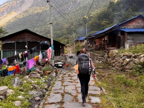
The trail travels from Lukla to Namche Bazaar, a busy Sherpa hub and crucial acclimatisation stop, via Phakding and the Dudh Koshi River.
From Namche, the trip continues to Kyanjuma and Tangnang, where the landscape changes from open alpine terrain to forested valleys, offering stunning views of the nearby peaks.
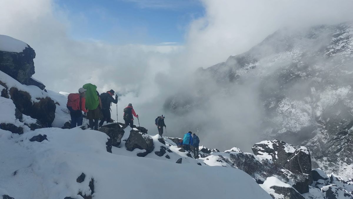
After passing through Thuli Kharka and Khare, the route enters high-altitude valleys with moraine ridges and streams fed by glaciers before arriving at Mera Base Camp, which serves as the summit push staging area.
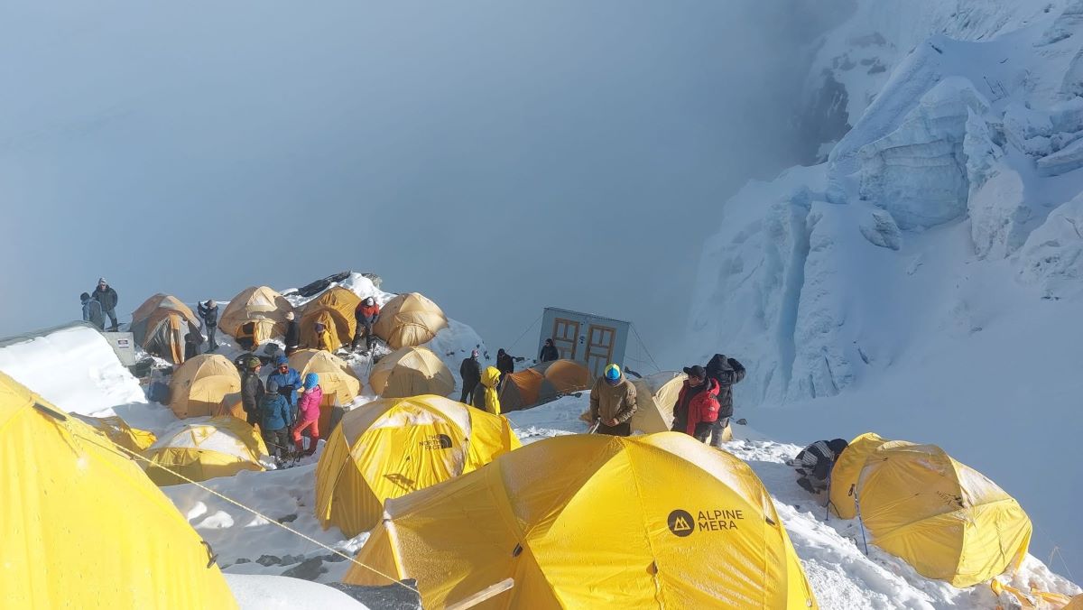
Climbers ascend from Base Camp to Mera High Camp (5,800 m), a strategic location for the early morning summit attempt. With sweeping views of Makalu, Cho Oyu, and Mount Everest, the final ascent to the 6,476-metre summit entails negotiating snow slopes, rocky ridges, and fixed rope sections.
The climbing map helps hikers visualise daily stages, camp locations, and terrain challenges to ensure safe and effective navigation throughout the expedition. The return trip follows the same trail in reverse.
Mount Glory Treks Team going down to High Camp after Mera Peak Submit
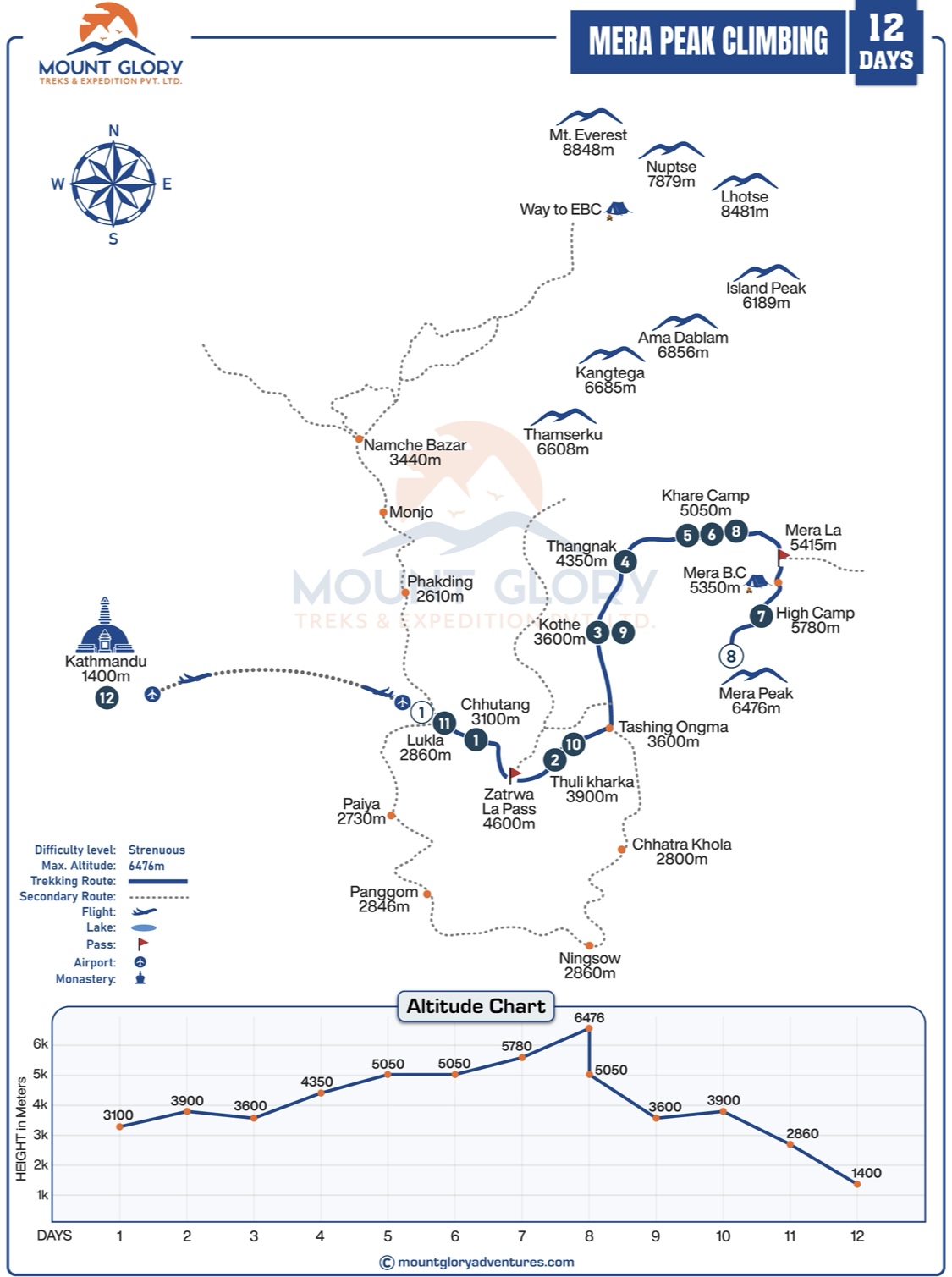
Standard Mera Peak Climbing 12 Days Itinerary
Day 01: Fly to Lukla and Trek to Chhutang.
Day 02: Trek to Thuli Kharka Via Zatrawala Pass.
Day 03: Trek to Kothe.
Day 04: Trek to Thangnak.
Day 05: Trek to Khare.
Day 06: Acclimatization at Khare.
Day 07: Hike to Mera High Camp.
Day 08: Climbing Mera Peak and Back to Khare.
Day 09: Trek to Kothe.
Day 10: Trek to Thuli Kharka.
Day 11: Trek to Lukla.
Day 12: Fly back to Kathmandu
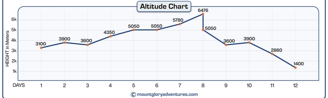
Mera Peak Climbing Altitude Chart Details
Mera Peak Climbing Map Sections
Lukla to Namche Bazaar
The journey begins in Lukla and progressively ascends through river valleys and wooded paths. The climbing map helps climbers navigate the first stage while acclimating to higher altitudes by highlighting important features like suspension bridges, trail junctions, and village crossings.
Namche Bazaar to Kyanjuma/Tangnang
The route from Namche travels through more tranquil high valleys after passing through the bustling Sherpa settlement. The map illustrates elevation gain with contour lines, showing changes in terrain and helping climbers plan daily distances and acclimatisation stops.
Tangnang/Sherpagaon to Thuli Kharka
Alpine meadows and changing vegetation zones are traversed in this section. Trekkers can see the path and surrounding terrain thanks to the map's clear indications of trail splits, grazing pastures, and route markers.
Thuli Kharka to Khare
As it gets closer to the glacial regions, the trail passes through moraine fields and valleys littered with stones. Rising altitude and narrowing valley corridors are depicted on the map, giving a clear idea of the challenges and steep terrain that lie ahead.
Khare to Mera Base Camp
The last route to Base Camp passes through high-altitude terrain with small streams and uneven paths. Map contours help with navigation and acclimatisation planning by marking campsite locations and indicating steep sections.
High Camp and Mera Summit Route
The map clearly indicates that Mera High Camp (~5,800 m) is situated near the nullah and snow slopes. To assist climbers in anticipating steep or exposed areas, the summit ridge and technical sections, such as snow and ice slopes and fixed rope segments, are marked. Contour density allows for safe planning and timing of the summit push by indicating the climb's difficulty.
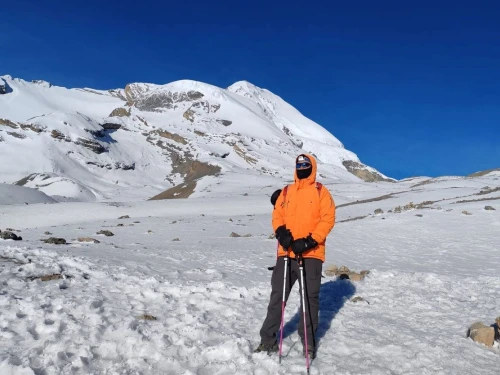
Preparing at Mera High Camp Before Expedition
Conclusion
For anyone planning this Himalayan journey, the Mera Peak Climbing Map is a vital resource. It gives climbers a clear idea of what to expect at each stage by helping them visualise the route, daily stages, campsites, and important terrain features. Planning acclimatisation, managing energy, and staying safe on snow slopes and ridges are all made easier when you study the map alongside your itinerary.
The map becomes even more useful when professional guides or seasoned Sherpas provide guidance, enabling you to navigate with confidence and make well-informed decisions. Climbers can concentrate on the experience, take in the breathtaking views, and have a safer, more satisfying summit attempt if they are aware of the route beforehand.
1: Why is a Mera Peak climbing map important for climbers? A climbing map shows all important camps, valleys, glacier areas, and snow slopes along the entire route from Lukla to the summit. It makes navigation safer and the expedition easier to handle by assisting climbers with daily stage planning, energy management, and technical section identification.
2: How can the map help plan the summit day effectively? High Camp, the summit ridge, and steep snow slopes are all clearly marked on the map, which aids climbers in anticipating difficult sections, scheduling their ascent, and setting up their equipment. A safer, well-paced summit push free of surprises is made possible by going over this information in advance.
3: Which camps and waypoints are highlighted on the Mera Peak map? Phakding, Namche Bazaar, Tangnang, Thuli Kharka, Khare, Base Camp, High Camp, and the summit are typically depicted on maps. Knowing these points allows climbers to plan daily distances, food and water requirements, and rest stops, as well as determining when additional acclimatisation is required.
4: Does the map show elevation gain for each section? Yes, contour lines and altitude markers show daily ascent and descent, which helps climbers plan acclimatisation days to lower the risk of altitude sickness and avoid rapid altitude gain.
5: Can the map improve safety during bad weather?
Absolutely. The map aids climbers in safely navigating through fog, snow, or poor visibility by displaying the terrain, valleys, ridges, and camp locations. If conditions worsen, climbers can find safe places to stop or retreat.
6: Are technical features like ropes, ice slopes, and glaciers shown on the map? Yes, the map helps climbers know where to use crampons, ice axes, and harnesses by highlighting fixed rope sections, crevasses, and steep snow slopes. This lowers risks during the summit push and enables better preparation.
7: How does studying the map help with gear and supplies planning? By displaying camp locations and distances, climbers can plan porter support, estimate food, water, oxygen, and clothing needs, and avoid carrying extra weight, all of which contribute to a more comfortable and effective climb.
8: Is a printed map necessary, or are digital maps sufficient? A physical map serves as a dependable backup in the event of a dead battery or a poor mobile signal, even though digital maps are more practical. Continuous orientation and confidence on the trail are ensured by combining the two.
9: Can climbers use the map to plan acclimatisation hikes? Yes, climbers can plan optional short hikes or additional rest days for proper acclimatisation before moving to High Camp, thanks to the clearly marked intermediate stops like Namche Bazaar, Tangnang, and Khare.
10: Does the map show alternate or emergency routes? Advanced maps can show viewpoints, emergency descent routes, and side trails so climbers can safely explore or have options in case the weather worsens or their energy levels decline.
11: How does using the map improve confidence for solo climbers? Solo climbers become more independent and self-assured when they are aware of the route, elevation, and campsite locations in advance. This allows them to foresee obstacles and safely navigate without constant supervision.
12: Can the map guide climbers to the best scenic viewpoints? Yes, climbers can schedule stops for photography, acclimatisation walks, or expansive views of Everest, Makalu, and Cho Oyu thanks to the marking of important ridges, glacier lines, and neighbouring peaks.
13: Should climbers rely on the map alone or combine it with a guide? A local guide or Sherpa's experience guarantees knowledge of current trail conditions, hidden hazards, and weather changes, making the summit experience safer and more pleasurable, even though the map offers crucial visual information.
14: How can the map help plan retreat or turnaround points? By highlighting important camps, elevation, and distances on the map, climbers can plan ahead for safe turnaround locations in case of inclement weather or exhaustion. This enables climbers to prioritise safety without squandering time or effort at high altitudes.
Born and raised in the Mountainous village of Gorkha Nepal. Mr. Pandey is a successful tour leader and a very active social worker contributing a lot to the welfare of society. Mr, Pandey belongs to a very humble background and has started his career as a junior staff in a much-reputed company in Nepal. Mr. Pandey's family background is engaged in the tourism sector for an extended period. After spending many years in research and the drawbacks of tourism development.
Due to his great passion and enthusiasm for the trekking and tourism sector, he started his tour career with many expert teams. He intends to bring revolution to the tourism sector by offering luxurious services and accommodations to travelers at a minimum price. With the Motto of Travellers, satisfaction is my passion. He has been helping many travelers with traveling.


.webp)