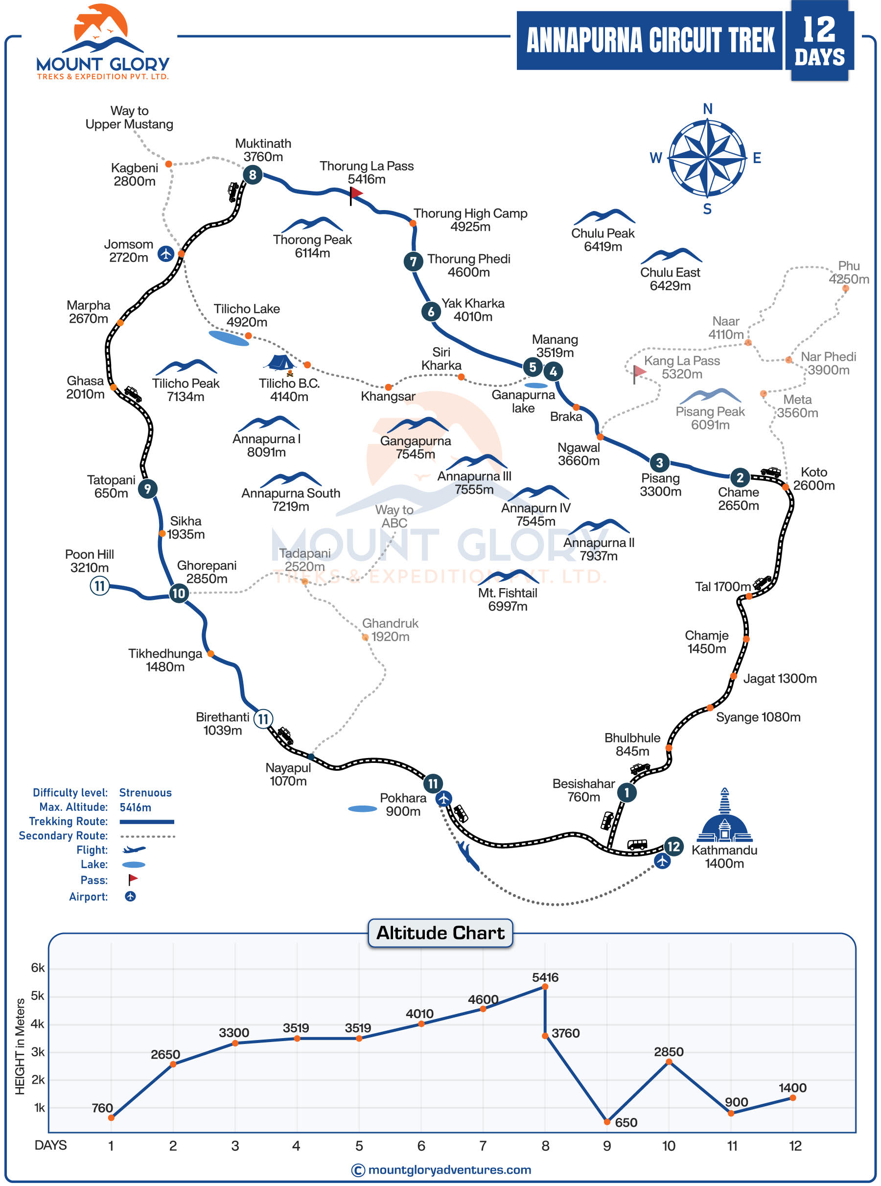
Annapurna Circuit Trek Map Location
Central Nepal is home to the Annapurna Circuit, which passes through the Annapurna Conservation Area (ACA).
It's interesting to note that Nepal's largest protected area, the Annapurna Conservation Area, is renowned for its traditional Himalayan settlements, mountain scenery, and biodiversity.
This trek to Annapurna Circuit circles through the Annapurna massif, including peaks like Annapurna I (8,091 m), Dhaulagiri (8,167 m), Manaslu (8,163 m) and Machhapuchhre (fishtail).
The map of the Annapurna Trek follows the Kali Gandaki Valley in the west and the Marsyangdi River Valley in the east.
Additionally, due to its central location, the circuit trek is easily accessible from Pokhara and Kathmandu.
The Annapurna Circuit Map travels through a number of central Nepalese districts, providing you with a wealth of geographical and cultural diversity.
The following major districts are covered:
- Lamjung District: the traditional starting zone and villages at lower elevations.
- Manang District: dry Himalayan terrain, high-altitude communities, and centres for acclimatisation.
- Mustang District: a rain-shadow region with Tibetan influences and arid landscapes.
The trek may also pass through portions of Myagdi or Kaski District, depending on the final route selected.
Similarly, our 12-day itinerary for the Annapurna Circuit Trek culminates in Pokhara in the Kaski district, followed by a picturesque drive to Kathmandu before our final departure.
Along the trekking map, each district's unique architecture, linguistic influences, and way of life are evident.
Annapurna Circuit Trek Map Route Overview
The itinerary and the starting and finishing locations you select will determine how long the Annapurna Circuit takes to complete.
Including detours and road avoidance trails, the entire Annapurna circuit typically spans 160–230 kilometres. The majority of hikers finish the route in 12 to 18 days, giving them ample time for rest days and acclimatisation.
Additionally, while longer versions include additional destinations like Poon Hill or the Annapurna Circuit Trek with Tilicho Lake, shorter itineraries frequently conclude at Pokhara.
Depending on the altitude, topography, and trail conditions, the daily walking distances during the Annapurna Circuit standard trek map normally range from 10 to 20 kilometres. Additionally, rather than depending solely on distance, the trekking map aids in visualising realistic daily stages.
The Annapurna Circuit route begins in the lower valley at relatively low elevations of 800–1000 metres before progressively rising to high altitude alpine terrain and crossing the Thorong La Pass at 5,416 metres, the trek's highest point.
Knowledge of the Annapurna map is crucial because the weather conditions close to the high pass can change quickly.
Traditionally, the Annapurna Circuit is trekked in a clockwise direction, beginning in the east and ending in the west. This direction permits a gradual increase in altitude, which is safer for acclimatisation.
It is evident from trekking maps that this is the most sensible and safe path for most hikers.
Annapurna Circuit Trek Map: Detailed Day-by-Day Itinerary (12 Days)
A well-defined route plan is crucial because the Annapurna Circuit Trek traverses a variety of terrain and elevations.
The 12-day itinerary is broken down day by day below, with important stops and trail highlights indicated on the Annapurna Circuit trek map. Trekkers can better grasp the trail's progression, altitude changes, and key locations by using this guide.
Day 01: Drive from Kathmandu to Besisahar
Besisahar is designated on the map as the official gateway to the Annapurna Circuit and Annapurna Conservation Area.
Day 02: Drive from Besisahar to Chame
The route passes through the valley of the Marsyangdi River, which is depicted on the map as the change from high-mountain terrain to road access.
Day 03: Trek from Chame to Upper Pisang
Upper Pisang is indicated as a higher and better acclimatisation stop on the map, which shows a gradual ascent into alpine terrain.
Day 04: Trek from Upper Pisang to Manang
The Upper Pisang route, which offers greater altitude gain than the lower trail, is clearly depicted on the map via Ghyaru and Ngawal.
Day 05: Acclimatisation Day in Manang
With side hikes to Gangapurna Lake and Ice Lake, Manang is identified on the map as a major acclimatisation hub.
Day 06: Trek from Manang to Yak Kharka
The map depicts gradual elevation gain and entry into high-altitude terrain above the tree line.
Day 07: Trek from Yak Kharka to Thorong Phedi
Thorong Phedi is designated as the last settlement prior to Thorong La Pass, highlighting the importance of meticulous altitude planning.
Day 08: Thorong Phedi to Muktinath, crossing the Thorong La Pass
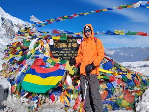
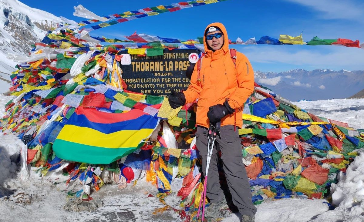
Thorong La Pass (5,416 m) is shown on the map as the trek's highest and most important point.
Day 09: Drive from Muktinath to Jomsom to Tatopani
The trek map makes it evident that the route descends along the Kali Gandaki Valley.
Day 10: Trek from Tatopani to Ghorepani
The map depicts a steep forest trail that links the Poon Hill route and the Annapurna Circuit.
Day 11: Trek from Ghorepani to Birethanti & Drive to Pokhara
Ghorepani is designated as a junction point, and the map displays the optional Poon Hill viewpoint.
Day 12: Drive from Pokhara to Kathmandu
On the map, Pokhara is shown as the Annapurna Circuit Trek's official destination.
Road Access & Trekking Trail in the Annapurna Circuit
The map of the Annapurna region displays a combination of contemporary jeep roads and traditional trekking routes along the Annapurna Circuit.
Trekking distances are now shortened by roads that connect places like Besisahar to Chame, Manang to Yak Kharka, and Muktinath to Tatopani.
Whereas traditional maps only show paths and trails, modern maps emphasise these road-access areas. Trekking trails, which offer more picturesque views, serene paths, and genuine village experiences, are still an option for avoiding roads.
Trekkers can plan daily stages and control altitude gain by using maps that show where roads intersect trails. For solo or guided hikers, using the updated map guarantees effective route planning, avoids traffic, and displays the best walking options.
Book 10 Days Annapurna Base Camp Trek with Mount Glory Treks
Annapurna Circuit Trek Elevation Profile
Planning the trek to the Annapurna Circuit and effectively managing energy requires an understanding of the daily altitude gain and loss. Altitude sickness is particularly dangerous in areas above 3,500 metres, such as Manang, Yak Kharka, Thorong Phedi, and Thorong La Pass.
In order to lower the risk of Acute Mountain Sickness (AMS), acclimatisation stops like Manang and Upper Pisang are essential.
Trekkers can safely plan walking hours, rest periods, and optional hikes with the aid of a clear daily elevation chart.
| Location | Elevation in meters |
| Kathmandu | 1400m |
| Besisahar | 760m |
| Chame | 2670m |
| Upper Pisang | 3300m |
| Manang | 3540m |
| Yak Kharka | 4050m |
| Thorong Phedi | 4520m |
| Thorong La Pass | 5416m |
| Muktinath | 3800m |
| Jomsom | 2700m |
| Tatopani | 1190m |
| Ghorepani | 2860m |
| Birethanti | 1025m |
| Pokhara | 820m |
How to Read an Annapurna Circuit Trek Map Properly
There are also proper and incorrect ways to read a trek map, and if you do not have the correct map information, problems may arise. Even though guided hikers depend on guides to help them navigate, understanding symbols, contour lines, and elevation can help you comprehend the trail and foresee obstacles.
To properly comprehend a map while hiking, bear the following points in mind:
- Symbols and contour lines: Learn how to identify trails, villages, rivers, bridges, and elevation changes. Contour lines indicate the slope's steepness.
- Distance vs. walking hours: Don't rely solely on kilometres when estimating trekking time; consider terrain, altitude gain, and trail conditions.
- Elevation awareness: To avoid altitude sickness, check acclimatisation stops and high-altitude locations.
- Weather and terrain interpretation: Plan safer trekking days and be prepared for exposed ridges, river crossings, and snow zones.
- Trail junctions and forks: Choose the best routes by identifying where paths split to prevent getting lost.
- Water and lodging locations: To schedule breaks, overnight stays, and hydration, locate villages and teahouses.
- Road vs. trail sections: To preserve the trekking experience, separate walking trails from jeep roads.
- Emergency locations: For safety, make a note of the locations of medical posts, checkpoints, and helipads.
- Seasonal considerations: Map symbols and elevation aid in seasonal planning; some trails may be blocked by snow or landslides.
Also Read: Everest Base Camp Trek 14 Days
In Conclusion
To complete the Trek to the Annapurna Circuit in a safe and comfortable manner, careful route planning is necessary.
Trekkers can better control their energy levels and lower the chance of altitude-related problems by being aware of daily distances, elevation changes, and acclimatisation points. Having a clear route overview boosts confidence and enhances decision-making throughout the journey, even if the trail is well-established.
The best trekking experience comes from combining a basic understanding of maps with a knowledgeable local guide.
Trekkers can stay informed, communicate more effectively, and fully appreciate the terrain and cultural landscape by knowing the route, even though the guide handles navigation, safety, and logistics.
A guided Annapurna round trek with Mount Glory Treks guarantees appropriate acclimatisation, flexible itineraries, and professional assistance throughout the trek for a secure and well-planned journey. Our staff is always available to help with route planning and itinerary customisation.
Annapurna Circuit Trek Map FAQs
1: Is the Annapurna Circuit route well-marked?
Yes, the main trail is usually clearly marked with stone piles and signs, particularly in the vicinity of villages and well-travelled areas. But some forks can be confusing, so it's best to have a guide or GPS with you.
2: Can beginners follow the Annapurna Circuit trek?
Yes, beginners with moderate fitness can complete the route, particularly on a guided trek with adequate acclimatisation. Mount Glory Treks offers packages for first-time trekkers.
3: Is GPS necessary for the trek?
Not strictly, since there are teahouses and popular trails. However, for optional routes or avoiding road sections, GPS or trekking apps like Maps.me can be helpful.
4: Does the route change seasonally?
Yes, certain areas may be impacted by landslides during the monsoon or snowfall in the winter. Always check seasonal updates before planning your walk, and stay in touch with us to ensure your trek is properly planned.
5: What is the cost of a guided Annapurna Circuit trek package?
The 12-day Manaslu Circuit Trek Package from Mount Glory Trek, which includes lodging, meals, a guide, and permits, costs between $970 and $1090 per person. The cost is determined by the number of hikers, and it goes down as the group size grows.
6: Which is the best season to trek the Annapurna Circuit?
For clear skies, consistent weather, and comfortable temperatures, spring (March–May) and autumn (September–November) are the best seasons. Winter is also possible, but you should practice extra caution and have prior experience.
7: Do I need previous trekking experience?
Not always. Beginners who are fit, properly acclimated, and have a knowledgeable guide can finish the Annapurna Circuit.
8: What permits are required?
You will need an ACAP (Annapurna Conservation Area Permit) and a TIMS (Trekkers' Information Management System) card. The permits are usually included in the package.
9: Can I customise the route or include side trips?
Yes, it is possible to add optional extensions like Poon Hill, Nar Phu Valley, or Tilicho Lake. Our guides can assist in customising the schedule.
10: How can I use the Annapurna Circuit Trek Map to plan my daily stages?
You can see daily distances, elevation gain, and rest locations with the Annapurna Circuit Trek Map. You can choose optional side trails while avoiding extremely long or steep stages, plan reasonable walking hours, and locate acclimatisation stops like Manang or Upper Pisang by looking at the map.
11: Is the Annapurna Circuit Trek Map suitable for beginners and solo trekkers?
The Annapurna Circuit Trek Map can help novices and lone hikers comprehend the route, important villages, and high-altitude portions. The map offers useful information about trail options, distances, and elevation changes, even though a guide is advised for safety.
12: What are the key points to check on an Annapurna Circuit Trek Map before starting the trek?
Examine elevation profiles, acclimatisation points, water and teahouse locations, and areas impacted by roads and weather before beginning. This guarantees that you are ready for high-altitude regions like Thorong La Pass and everyday walking challenges.
13: Which is the best company for the Annapurna Circuit trek in Nepal?
A trustworthy operator like Mount Glory Treks, along with a basic understanding of elevation, daily distances, and acclimatisation points, is the ideal company for the Annapurna Circuit Trek.

 2 reviews